
Spenden
Topografische Karte Front Royal
Klicken Sie auf die Karte, um die Höhe anzuzeigen.
Spenden
Front Royal
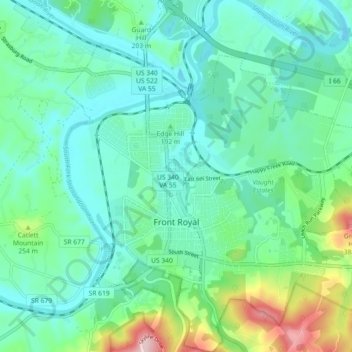
Front Royal, located in Warren County, Virginia, sits at an elevation of approximately 570 feet (174 meters) above sea level. It lies in a diverse topographic region, with the town nestled at the confluence of the North and South Forks of the Shenandoah River, which contributes to its distinctive river valley landscape. The surrounding terrain is marked by rolling hills and moderate elevation changes, with some areas rising into the foothills of the Blue Ridge Mountains to the east. The area's proximity to these mountains results in a natural divide, with the town situated in a relatively low-lying area within the larger Shenandoah Valley.
Spenden
Über diese Karte
Name: Topografische Karte Front Royal, Höhe, Relief.
Ort: Front Royal, Warren County, Virginia, United States (38.89164 -78.22068 38.96222 -78.14276)
Durchschnittliche Höhe: 194 m
Minimale Höhe: 132 m
Maximale Höhe: 408 m
Spenden
Andere topografische Karten
Klicken Sie auf eine Karte, um ihre Topografie, ihre Höhe und ihr Relief anzuzeigen.