
Topografische Karte Brosna
Interaktive Karte
Klicken Sie auf die Karte, um die Höhe anzuzeigen.
Über diese Karte
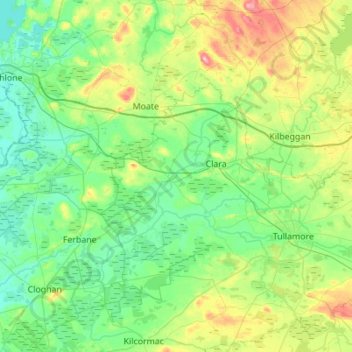
Name: Topografische Karte Brosna, Höhe, Relief.
Ort: Brosna, County Offaly, Leinster, Ireland (53.21763 -7.97081 53.44375 -7.41951)
Durchschnittliche Höhe: 69 m
Minimale Höhe: 31 m
Maximale Höhe: 191 m
Works, to the cost of IR £750,000, were undertaken on the river in the late 1940s and early 1950s to improve drainage in the river’s catchment area. As part of the Arterial Drainage Scheme, designed to tackle poor drainage caused by Ireland’s relatively low-lying topography, the river was deepened and widened, leaving the river with the high banks distinctive of many of the rivers in the Irish midlands that received this treatment. More recently, in late 2008 the river was diverted from the N52 road beside Mullingar in order to accommodate a new roundabout and bridge.
Andere topografische Karten
Klicken Sie auf eine Karte, um ihre Topografie, ihre Höhe und ihr Relief anzuzeigen.
Moorock
Moorock, Ballycumber ED, The Municipal District of Tullamore, County Offaly, Leinster, Ireland
Durchschnittliche Höhe: 64 m
Mount Lucas
Mount Lucas, Esker ED, The Municipal District of Edenderry, County Offaly, Leinster, R35 XW10, Ireland
Durchschnittliche Höhe: 76 m
Durrow
Durrow, The Municipal District of Tullamore, County Offaly, Leinster, R35 X865, Ireland
Durchschnittliche Höhe: 66 m
Tullamore
Tullamore, The Municipal District of Tullamore, County Offaly, Leinster, Ireland
Durchschnittliche Höhe: 65 m
Shannonbridge
Shannonbridge, Shannonbridge ED, The Municipal District of Birr, County Offaly, Leinster, Ireland
Durchschnittliche Höhe: 38 m
Daingean
Daingean, Daingean ED, The Municipal District of Edenderry, County Offaly, Leinster, Ireland
Durchschnittliche Höhe: 82 m
The Municipal District of Edenderry
The Municipal District of Edenderry, County Offaly, Leinster, Ireland
Durchschnittliche Höhe: 80 m
Rath
Rath, Drumcullen ED, The Municipal District of Birr, County Offaly, Leinster, Ireland
Durchschnittliche Höhe: 66 m
Ballycommon
Ballycommon, The Municipal District of Edenderry, County Offaly, Leinster, Ireland
Durchschnittliche Höhe: 80 m
Shinrone
Ireland > County Offaly > The Municipal District of Birr
Shinrone, The Municipal District of Birr, County Offaly, Leinster, Ireland
Durchschnittliche Höhe: 72 m
Ballykilleen
Ballykilleen, Edenderry Rural ED, The Municipal District of Edenderry, County Offaly, Leinster, Ireland
Durchschnittliche Höhe: 75 m
Geashill
Geashill, Geashill ED, The Municipal District of Edenderry, County Offaly, Leinster, Ireland
Durchschnittliche Höhe: 88 m
Shinrone
Shinrone, Shinrone ED, The Municipal District of Birr, County Offaly, Leinster, Ireland
Durchschnittliche Höhe: 72 m
Kilcormac ED
Ireland > County Offaly > The Municipal District of Birr
Kilcormac ED, The Municipal District of Birr, County Offaly, Leinster, R42 RC92, Ireland
Durchschnittliche Höhe: 69 m
Ballybritt
Ireland > County Offaly > The Municipal District of Birr
Ballybritt, Aghancon ED, The Municipal District of Birr, County Offaly, Leinster, Ireland
Durchschnittliche Höhe: 146 m
Rahan
Ireland > County Offaly > Rahan
Rahan, The Municipal District of Tullamore, County Offaly, Leinster, Ireland
Durchschnittliche Höhe: 53 m
Charlestown
Ireland > County Offaly > Charlestown
Charlestown, Clara ED, The Municipal District of Tullamore, County Offaly, Leinster, Ireland
Durchschnittliche Höhe: 61 m
Banagher
Ireland > County Offaly > Banagher
Banagher, The Municipal District of Birr, County Offaly, Leinster, R42 DE61, Ireland
Durchschnittliche Höhe: 43 m
Kinnitty Parish
Kinnitty Parish, County Offaly, Leinster, R42 W542, Ireland
Durchschnittliche Höhe: 202 m
Lumcloon
Lumcloon, Gallen ED, The Municipal District of Birr, County Offaly, Leinster, Ireland
Durchschnittliche Höhe: 50 m
Rathmoyle
Rathmoyle, Ballyburly ED, The Municipal District of Edenderry, County Offaly, Leinster, Ireland
Durchschnittliche Höhe: 88 m
Seir Kieran
Ireland > County Offaly > The Municipal District of Birr
Seir Kieran, The Municipal District of Birr, County Offaly, Leinster, Ireland
Durchschnittliche Höhe: 143 m
The Municipal District of Tullamore
The Municipal District of Tullamore, County Offaly, Leinster, Ireland
Durchschnittliche Höhe: 73 m
The Municipal District of Birr
The Municipal District of Birr, County Offaly, Leinster, Ireland
Durchschnittliche Höhe: 97 m