Geolokalisieren
👉 Easily get elevation data in JSON, GeoTIFF and KML formats using Elevation API
Vielen Dank für die Unterstützung dieser Website ❤️
Spenden

Topografische Karte Shinrone

Klicken Sie auf die Karte, um die Höhe anzuzeigen.

👉 Easily get elevation data in JSON, GeoTIFF and KML formats using Elevation API
Vielen Dank für die Unterstützung dieser Website ❤️
Spenden

Über diese Karte

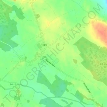
Name: Topografische Karte Shinrone, Höhe, Relief.

Ort: Shinrone, Shinrone ED, The Municipal District of Birr, County Offaly, Leinster, Ireland (52.97378 -7.93625 52.99601 -7.90186)

Durchschnittliche Höhe: 72 m

Minimale Höhe: 51 m

Maximale Höhe: 96 m

👉 Easily get elevation data in JSON, GeoTIFF and KML formats using Elevation API
Vielen Dank für die Unterstützung dieser Website ❤️
Spenden

Andere topografische Karten

Klicken Sie auf eine Karte, um ihre Topografie, ihre Höhe und ihr Relief anzuzeigen.

Croghan

Ireland > County Offaly

Durchschnittliche Höhe: 100 m

Cappincur

Ireland > County Offaly

Durchschnittliche Höhe: 65 m

Harbour

Ireland > County Offaly

Durchschnittliche Höhe: 62 m

Vielen Dank für die Unterstützung dieser Website ❤️
Spenden

Ballycommon

Ireland > County Offaly

Durchschnittliche Höhe: 80 m

Rath

Ireland > County Offaly

Durchschnittliche Höhe: 66 m

Daingean

Ireland > County Offaly

Durchschnittliche Höhe: 82 m

Durrow

Ireland > County Offaly

Durchschnittliche Höhe: 66 m

Vielen Dank für die Unterstützung dieser Website ❤️
Spenden

Mount Lucas

Ireland > County Offaly

Durchschnittliche Höhe: 76 m

Coolderry

Ireland > County Offaly

Durchschnittliche Höhe: 107 m

Rahan

Ireland > County Offaly

Durchschnittliche Höhe: 53 m

Banagher

Ireland > County Offaly > Banagher

Durchschnittliche Höhe: 43 m

Vielen Dank für die Unterstützung dieser Website ❤️
Spenden

Charlestown

Ireland > County Offaly > Charlestown

Durchschnittliche Höhe: 61 m

Rahan

Ireland > County Offaly

Durchschnittliche Höhe: 53 m