
Spenden
Topografische Karte Gibaja
Klicken Sie auf die Karte, um die Höhe anzuzeigen.
Spenden
Über diese Karte
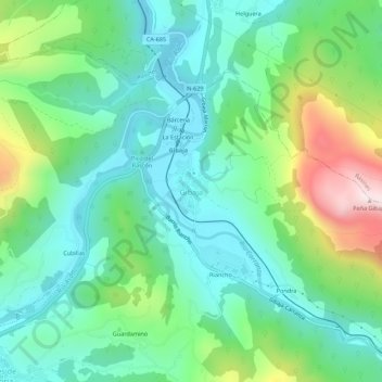
Name: Topografische Karte Gibaja, Höhe, Relief.
Ort: Gibaja, Ramales de la Victoria, Cantabria, 39809, Spain (43.25679 -3.45642 43.29679 -3.41642)
Durchschnittliche Höhe: 212 m
Minimale Höhe: 36 m
Maximale Höhe: 663 m
Spenden
Andere topografische Karten
Klicken Sie auf eine Karte, um ihre Topografie, ihre Höhe und ihr Relief anzuzeigen.
Cantabria
Towards the south are higher mountains, the tops of which form the watershed between the drainage basins of the Rivers Ebro, Duero and the rivers that flow into the Bay of Biscay. These peaks generally exceed 1,500 m (4,900 ft) from the Pass of San Glorio in the west to the Pass of Los Tornos in the eastern…
Durchschnittliche Höhe: 609 m
Potes
The town of Potes is located at the confluence of four valleys, near where the River Quiviesa flows in the River Deva, the latter born at altitudes of the Picos de Europa. Like the rest of the Liébana region, Potes enjoys a Mediterranean microclimate that allows the cultivation of the vines, walnut and…
Durchschnittliche Höhe: 490 m
Spenden
African Elephant, Water Buffalo and Southern Lechwe
Spain > Cantabria > Penagos > Cabárceno
Durchschnittliche Höhe: 191 m
Potes
The town of Potes is located at the confluence of four valleys, near where the River Quiviesa flows in the River Deva, the latter born at altitudes of the Picos de Europa. Like the rest of the Liébana region, Potes enjoys a Mediterranean microclimate that allows the cultivation of the vines, walnut and…
Durchschnittliche Höhe: 490 m
Spenden
Spenden
Spenden
Spenden
Spenden
Spenden
Spenden