
Spenden
Topografische Karte Potes
Klicken Sie auf die Karte, um die Höhe anzuzeigen.
Spenden
Potes
The town of Potes is located at the confluence of four valleys, near where the River Quiviesa flows in the River Deva, the latter born at altitudes of the Picos de Europa. Like the rest of the Liébana region, Potes enjoys a Mediterranean microclimate that allows the cultivation of the vines, walnut and poplar. Overlooking the town is Arabedes mountain (694m).
Spenden
Über diese Karte
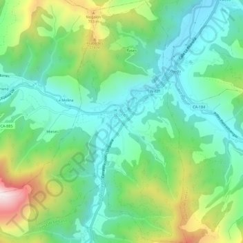
Name: Topografische Karte Potes, Höhe, Relief.
Ort: Potes, Cantabria, 39570, Spain (43.13238 -4.64489 43.17275 -4.60865)
Durchschnittliche Höhe: 490 m
Minimale Höhe: 253 m
Maximale Höhe: 1.047 m
Spenden
Andere topografische Karten
Klicken Sie auf eine Karte, um ihre Topografie, ihre Höhe und ihr Relief anzuzeigen.
African Elephant, Water Buffalo and Southern Lechwe
Spain > Cantabria > Penagos > Cabárceno
Durchschnittliche Höhe: 191 m
Spenden
Spenden
Spenden
Spenden
Spenden
Spenden
Spenden
Spenden
Spenden
Spenden
Spenden
Pontones
Spain > Cantabria > Ribamontán al Monte > Villaverde de Pontones
Durchschnittliche Höhe: 62 m
Spenden