Geolokalisieren
👉 Easily get elevation data in JSON, GeoTIFF and KML formats using Elevation API
Vielen Dank für die Unterstützung dieser Website ❤️
Spenden

Topografische Karte Bristol Port Railway

Klicken Sie auf die Karte, um die Höhe anzuzeigen.

👉 Easily get elevation data in JSON, GeoTIFF and KML formats using Elevation API
Vielen Dank für die Unterstützung dieser Website ❤️
Spenden

Über diese Karte

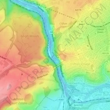
Name: Topografische Karte Bristol Port Railway, Höhe, Relief.

Ort: Bristol Port Railway, Bridge Valley Road, Clifton, Bristol, City of Bristol, South West England, England, BS8, United Kingdom (51.45733 -2.62924 51.45760 -2.62903)

Durchschnittliche Höhe: 68 m

Minimale Höhe: -14 m

Maximale Höhe: 136 m

👉 Easily get elevation data in JSON, GeoTIFF and KML formats using Elevation API
Vielen Dank für die Unterstützung dieser Website ❤️
Spenden

Andere topografische Karten

Klicken Sie auf eine Karte, um ihre Topografie, ihre Höhe und ihr Relief anzuzeigen.

Brandon Hill

United Kingdom > England > City of Bristol > Bristol

Durchschnittliche Höhe: 39 m

Whitchurch Park Ward

United Kingdom > England > City of Bristol > Bristol

Durchschnittliche Höhe: 91 m

Troopers Hill

United Kingdom > England > City of Bristol > Bristol

Durchschnittliche Höhe: 56 m

Stoke Park Estate

United Kingdom > England > City of Bristol > Bristol

Durchschnittliche Höhe: 57 m

Vielen Dank für die Unterstützung dieser Website ❤️
Spenden

The Arches

United Kingdom > England > City of Bristol > Bristol

Durchschnittliche Höhe: 50 m

Observatory Hill

United Kingdom > England > City of Bristol > Bristol

Durchschnittliche Höhe: 64 m

White Ladies Gate

United Kingdom > England > City of Bristol > Bristol

Durchschnittliche Höhe: 63 m

Cherry Orchards

United Kingdom > England > City of Bristol > Bristol

Durchschnittliche Höhe: 47 m

Vielen Dank für die Unterstützung dieser Website ❤️
Spenden

Observatory Hill

United Kingdom > England > City of Bristol > Bristol

Durchschnittliche Höhe: 64 m