
Topografische Karte Wasatch Range
Interaktive Karte
Klicken Sie auf die Karte, um die Höhe anzuzeigen.
Über diese Karte
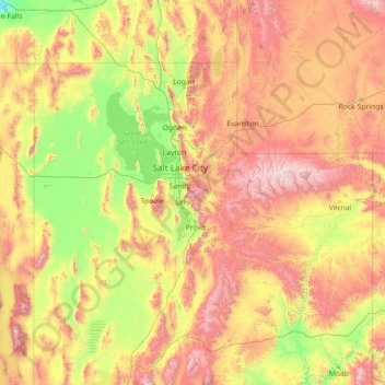
Name: Topografische Karte Wasatch Range, Höhe, Relief.
Ort: Wasatch Range, Salt Lake County, Utah, USA (38.36966 -111.92048 42.68042 -111.08277)
Durchschnittliche Höhe: 1.880 m
Minimale Höhe: 1.109 m
Maximale Höhe: 4.021 m
Andere topografische Karten
Klicken Sie auf eine Karte, um ihre Topografie, ihre Höhe und ihr Relief anzuzeigen.
Grand Staircase-Escalante National Monument
Grand Staircase-Escalante National Monument, Left Hand Collet Road, Kane County, Utah, USA
Durchschnittliche Höhe: 1.857 m
Antelope Island State Park
Antelope Island State Park, Antelope Island Road, Davis County, Utah, USA
Durchschnittliche Höhe: 1.314 m
Glen Canyon National Recreation Area
Glen Canyon National Recreation Area, Moody Creek Road, Garfield County, Utah, USA
Durchschnittliche Höhe: 1.798 m
La Sal Mountains Viewpoint
La Sal Mountains Viewpoint, Arches Entrance Road, Grand County, Utah, 84532-2134, USA
Durchschnittliche Höhe: 1.347 m
Timpanogos Glacier
USA > Utah > Aspen Grove
Timpanogos Glacier, Mount Timpanogos Trail #052, Aspen Grove, Utah County, Utah, USA
Durchschnittliche Höhe: 3.148 m
Fishlake National Forest
Fishlake National Forest, US Forest Service Road 1782, Garfield County, Utah, USA
Durchschnittliche Höhe: 2.075 m
Lake Fork River
Lake Fork River, Duchesne County, Utah, 84001, USA
Durchschnittliche Höhe: 1.992 m