
Topografische Karte Fishlake National Forest
Interaktive Karte
Klicken Sie auf die Karte, um die Höhe anzuzeigen.
Über diese Karte
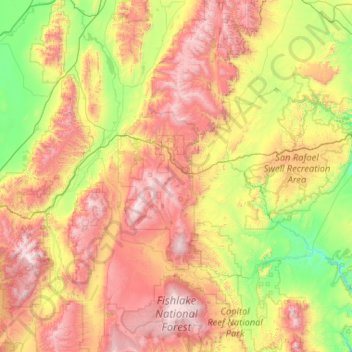
Name: Topografische Karte Fishlake National Forest, Höhe, Relief.
Durchschnittliche Höhe: 2.075 m
Minimale Höhe: 1.275 m
Maximale Höhe: 3.681 m
Andere topografische Karten
Klicken Sie auf eine Karte, um ihre Topografie, ihre Höhe und ihr Relief anzuzeigen.
Grand Staircase-Escalante National Monument
Grand Staircase-Escalante National Monument, Left Hand Collet Road, Kane County, Utah, USA
Durchschnittliche Höhe: 1.857 m
Antelope Island State Park
Antelope Island State Park, Antelope Island Road, Davis County, Utah, USA
Durchschnittliche Höhe: 1.314 m
Glen Canyon National Recreation Area
Glen Canyon National Recreation Area, Moody Creek Road, Garfield County, Utah, USA
Durchschnittliche Höhe: 1.798 m
La Sal Mountains Viewpoint
La Sal Mountains Viewpoint, Arches Entrance Road, Grand County, Utah, 84532-2134, USA
Durchschnittliche Höhe: 1.347 m
Timpanogos Glacier
USA > Utah > Aspen Grove
Timpanogos Glacier, Mount Timpanogos Trail #052, Aspen Grove, Utah County, Utah, USA
Durchschnittliche Höhe: 3.148 m
Lake Fork River
Lake Fork River, Duchesne County, Utah, 84001, USA
Durchschnittliche Höhe: 1.992 m