
Topografische Karte Hangatiki
Interaktive Karte
Klicken Sie auf die Karte, um die Höhe anzuzeigen.
Über diese Karte
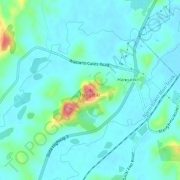
Name: Topografische Karte Hangatiki, Höhe, Relief.
Ort: Hangatiki, Waitomo District, Waikato, 3977, New Zealand (-38.25511 175.17211 -38.25501 175.17221)
Durchschnittliche Höhe: 54 m
Minimale Höhe: 37 m
Maximale Höhe: 139 m
Andere topografische Karten
Klicken Sie auf eine Karte, um ihre Topografie, ihre Höhe und ihr Relief anzuzeigen.
King Country
New Zealand > Waikato > Waitomo District
King Country, Waitomo District, Waikato, New Zealand
Durchschnittliche Höhe: 296 m
Awakino
New Zealand > Waikato > Waitomo District
Awakino, Waitomo District, Waikato, New Zealand
Durchschnittliche Höhe: 37 m
Te Kuiti
New Zealand > Waikato > Waitomo District
Te Kuiti, Waitomo District, Waikato, 3910, New Zealand
Durchschnittliche Höhe: 130 m
Marokopa River
New Zealand > Waikato > Waitomo District
Marokopa River, Waitomo District, Waikato, New Zealand
Durchschnittliche Höhe: 216 m