
Topografische Karte King Country
Interaktive Karte
Klicken Sie auf die Karte, um die Höhe anzuzeigen.
Über diese Karte
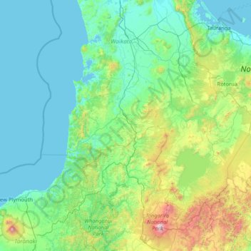
Name: Topografische Karte King Country, Höhe, Relief.
Ort: King Country, Waitomo District, Waikato, New Zealand (-39.46595 174.21583 -37.46595 176.21583)
Durchschnittliche Höhe: 296 m
Minimale Höhe: 0 m
Maximale Höhe: 2.717 m
Andere topografische Karten
Klicken Sie auf eine Karte, um ihre Topografie, ihre Höhe und ihr Relief anzuzeigen.
Awakino
New Zealand > Waikato > Waitomo District
Awakino, Waitomo District, Waikato, New Zealand
Durchschnittliche Höhe: 37 m
Te Kuiti
New Zealand > Waikato > Waitomo District
Te Kuiti, Waitomo District, Waikato, 3910, New Zealand
Durchschnittliche Höhe: 130 m
Hangatiki
New Zealand > Waikato > Waitomo District
Hangatiki, Waitomo District, Waikato, 3977, New Zealand
Durchschnittliche Höhe: 54 m
Marokopa River
New Zealand > Waikato > Waitomo District
Marokopa River, Waitomo District, Waikato, New Zealand
Durchschnittliche Höhe: 216 m