
Spenden
Topografische Karte North District
Klicken Sie auf die Karte, um die Höhe anzuzeigen.
Spenden
Über diese Karte
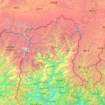
Name: Topografische Karte North District, Höhe, Relief.
Ort: North District, Mangan, Sikkim, India (26.96667 87.80000 28.36667 89.20000)
Durchschnittliche Höhe: 3.760 m
Minimale Höhe: 258 m
Maximale Höhe: 8.489 m
Spenden
Andere topografische Karten
Klicken Sie auf eine Karte, um ihre Topografie, ihre Höhe und ihr Relief anzuzeigen.
Mangan
Mangan is the largest of the six districts of Sikkim. The landscape is mountainous with dense vegetation all the way up to the alpine altitude before thinning out to desert scrub towards the northern tundra. Numerous waterfalls astride the main road make the trip to this district extremely picturesque.
Durchschnittliche Höhe: 4.407 m
Spenden
West Sikkim District
West Sikkim (now officially named as Geyzing District) is a district of the Indian state of Sikkim. Its headquarter is Geyzing, also known as Gyalshing. The district is a favourite with trekkers due to the high elevations. Other important towns include Pelling and Yuksom. Local people also call it as…
Durchschnittliche Höhe: 2.686 m
Spenden
Spenden
Spenden
Spenden
Gurudongmar
India > Sikkim > Chungthang
Gurudongmar Lake is one of the highest lakes in the world and in India, at an elevation of 5,430 m (17,800 ft) according to the Government of Sikkim. It is located in the Great Himalayas in the Mangan District in Indian state of Sikkim, and considered sacred by Buddhists and Sikhs. The lake is named after…
Durchschnittliche Höhe: 5.232 m
Mangan
Mangan is the largest of the six districts of Sikkim. The landscape is mountainous with dense vegetation all the way up to the alpine altitude before thinning out to desert scrub towards the northern tundra. Numerous waterfalls astride the main road make the trip to this district extremely picturesque.
Durchschnittliche Höhe: 4.407 m
Spenden
Spenden