
Spenden
Topografische Karte Zemu Glacier
Klicken Sie auf die Karte, um die Höhe anzuzeigen.
Spenden
Über diese Karte
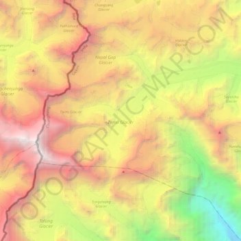
Name: Topografische Karte Zemu Glacier, Höhe, Relief.
Ort: Zemu Glacier, Chungthang, Mangan, Sikkim, India (27.67205 88.15984 27.76892 88.38372)
Durchschnittliche Höhe: 5.510 m
Minimale Höhe: 2.412 m
Maximale Höhe: 8.587 m
Spenden
Andere topografische Karten
Klicken Sie auf eine Karte, um ihre Topografie, ihre Höhe und ihr Relief anzuzeigen.
Kangchenjunga
India > Sikkim > Chungthang
Kangchenjunga Main is the highest elevation of the Brahmaputra River basin, which forms part of the southeast Asian monsoon regime and is among the globally largest river basins. Kangchenjunga is one of six peaks above 8,000 m (26,000 ft) located in the basin of the Kosi River, which is among the largest…
Durchschnittliche Höhe: 7.725 m
Lachung
India > Sikkim > Chungthang
Lachung is a town and hill station in Mangan district in northeast Indian state of Sikkim. It is approx. 50 km Mangan town, the district headquarters. It is located in the Mangan district near the border with Tibet. Lachung is at an elevation of about 9,600 feet (2,900 m) and at the confluence of the Lachen…
Durchschnittliche Höhe: 3.617 m
Spenden
Kangchenjunga
India > Sikkim > Chungthang
Kangchenjunga Main is the highest elevation of the Brahmaputra River basin, which forms part of the southeast Asian monsoon regime and is among the globally largest river basins. Kangchenjunga is one of six peaks above 8,000 m (26,000 ft) located in the basin of the Kosi River, which is among the largest…
Durchschnittliche Höhe: 7.725 m
Spenden
Kangchenjunga
India > Sikkim > Chungthang
Kangchenjunga Main is the highest elevation of the Brahmaputra River basin, which forms part of the southeast Asian monsoon regime and is among the globally largest river basins. Kangchenjunga is one of six peaks above 8,000 m (26,000 ft) located in the basin of the Kosi River, which is among the largest…
Durchschnittliche Höhe: 7.725 m
Lachung
India > Sikkim > Chungthang
Lachung is a town and hill station in northeast Sikkim, India. It is located in the North Sikkim district near the border with Tibet. Lachung is at an elevation of about 9,600 feet (2,900 m) and at the confluence of the Lachen and Lachung Rivers, both tributaries of the River Teesta. The word Lachung means…
Durchschnittliche Höhe: 3.617 m