
Spenden
Topografische Karte Belmont
Klicken Sie auf die Karte, um die Höhe anzuzeigen.
Spenden
Über diese Karte
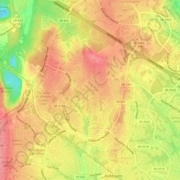
Name: Topografische Karte Belmont, Höhe, Relief.
Ort: Belmont, Loudoun County, Virginia, 20147, United States (39.04278 -77.51417 39.08278 -77.47417)
Durchschnittliche Höhe: 93 m
Minimale Höhe: 32 m
Maximale Höhe: 127 m
Spenden
Andere topografische Karten
Klicken Sie auf eine Karte, um ihre Topografie, ihre Höhe und ihr Relief anzuzeigen.
Ashburn
United States > Virginia > Loudoun County > Ashburn
Ashburn is located at 39°02′37″N 077°29′15″W / 39.04361°N 77.48750°W / 39.04361; -77.48750 (39.0437192, −77.4874899) and its average elevation is 295 feet (90 m) above sea level. According to the 2010 United States Census, the CDP has a total area of 17.287 square miles (44.77 km2), of…
Durchschnittliche Höhe: 86 m
Leesburg
United States > Virginia > Loudoun County
Leesburg is located northeast of the center of Loudoun County at 39°7′N 77°33′W / 39.117°N 77.550°W / 39.117; -77.550 (39.109, −77.558), It is part of the northern Virginia Piedmont and sits at the base of the easternmost chain of the Blue Ridge Mountains, Catoctin Mountain. The town lies in…
Durchschnittliche Höhe: 113 m
Sterling
United States > Virginia > Loudoun County > Sterling
According to the USGS, Sterling has an average elevation of 289 feet (88 m) above sea level. The original center of Sterling is located at 39°00'22.4"N 77°25'43.0"W. Sterling is part of the Chesapeake Bay watershed, and Greater Sterling borders the Potomac River.
Durchschnittliche Höhe: 97 m
Spenden
Spenden
Goose Creek
United States > Virginia > Loudoun County > Goose Creek Village
Durchschnittliche Höhe: 91 m
Spenden
Middleburg
United States > Virginia > Loudoun County
According to the United States Census Bureau, the town has a total area of 0.6 square mile (1.5 km2), all land. The elevation is 486 feet.
Durchschnittliche Höhe: 143 m
Spenden
Leesburg
United States > Virginia > Loudoun County
Leesburg is located northeast of the center of Loudoun County at 39°7′N 77°33′W / 39.117°N 77.550°W / 39.117; -77.550 (39.109, −77.558), It is part of the northern Virginia Piedmont and sits at the base of the easternmost chain of the Blue Ridge Mountains, Catoctin Mountain. The town lies in…
Durchschnittliche Höhe: 113 m
Middleburg
United States > Virginia > Loudoun County
According to the United States Census Bureau, the town has a total area of 0.6 square mile (1.5 km2), all land. The elevation is 486 feet.
Durchschnittliche Höhe: 143 m
Middleburg
United States > Virginia > Loudoun County
According to the United States Census Bureau, the town has a total area of 0.6 square mile (1.5 km2), all land. The elevation is 486 feet.
Durchschnittliche Höhe: 143 m
Spenden
Sterling
United States > Virginia > Loudoun County
According to the USGS, Sterling has an average elevation of 289 feet (88 m) above sea level. The original center of Sterling is located at 39°00'22.4"N 77°25'43.0"W. Sterling is part of the Chesapeake Bay watershed, and Greater Sterling borders the Potomac River.
Durchschnittliche Höhe: 97 m
Ashburn
United States > Virginia > Loudoun County > Ashburn
Ashburn is located in eastern Loudoun County at 39°02′37″N 077°29′15″W / 39.04361°N 77.48750°W / 39.04361; -77.48750 (39.0437192, −77.4874899) and its average elevation is 295 feet (90 m) above sea level. It is 7 miles (11 km) southeast of Leesburg, the county seat, and the same distance…
Durchschnittliche Höhe: 86 m
Spenden
Spenden
Ashburn
United States > Virginia > Loudoun County > Ashburn
Ashburn is located in eastern Loudoun County at 39°02′37″N 077°29′15″W / 39.04361°N 77.48750°W / 39.04361; -77.48750 (39.0437192, −77.4874899) and its average elevation is 295 feet (90 m) above sea level. It is 7 miles (11 km) southeast of Leesburg, the county seat, and the same distance…
Durchschnittliche Höhe: 86 m