Geolokalisieren
👉 Easily get elevation data in JSON, GeoTIFF and KML formats using Elevation API
Vielen Dank für die Unterstützung dieser Website ❤️
Spenden

Topografische Karte Percy Boom

Klicken Sie auf die Karte, um die Höhe anzuzeigen.

👉 Easily get elevation data in JSON, GeoTIFF and KML formats using Elevation API
Vielen Dank für die Unterstützung dieser Website ❤️
Spenden

Über diese Karte

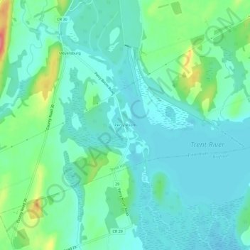
Name: Topografische Karte Percy Boom, Höhe, Relief.

Ort: Percy Boom, Trent Hills, Northumberland County, Central Ontario, Ontario, Canada (44.21577 -77.82284 44.25577 -77.78284)

Durchschnittliche Höhe: 127 m

Minimale Höhe: 109 m

Maximale Höhe: 184 m

👉 Easily get elevation data in JSON, GeoTIFF and KML formats using Elevation API
Vielen Dank für die Unterstützung dieser Website ❤️
Spenden

Andere topografische Karten

Klicken Sie auf eine Karte, um ihre Topografie, ihre Höhe und ihr Relief anzuzeigen.

Trent River

Canada > Ontario > Northumberland County > Trent Hills

Durchschnittliche Höhe: 138 m

Trent River

Canada > Ontario > Northumberland County > Trent Hills > Trent River

Durchschnittliche Höhe: 197 m

O'Reilly Lake

Canada > Ontario > Northumberland County > Trent Hills

Durchschnittliche Höhe: 220 m

Vielen Dank für die Unterstützung dieser Website ❤️
Spenden

Rylestone Lake

Canada > Ontario > Northumberland County > Trent Hills

Durchschnittliche Höhe: 187 m

Burnley Creek

Canada > Ontario > Northumberland County > Trent Hills

Durchschnittliche Höhe: 213 m

Hardy Island

Canada > Ontario > Northumberland County > Trent Hills

Durchschnittliche Höhe: 187 m