Geolokalisieren
👉 Easily get elevation data in JSON, GeoTIFF and KML formats using Elevation API
Vielen Dank für die Unterstützung dieser Website ❤️
Spenden

Topografische Karte Hardy Island

Klicken Sie auf die Karte, um die Höhe anzuzeigen.

👉 Easily get elevation data in JSON, GeoTIFF and KML formats using Elevation API
Vielen Dank für die Unterstützung dieser Website ❤️
Spenden

Über diese Karte

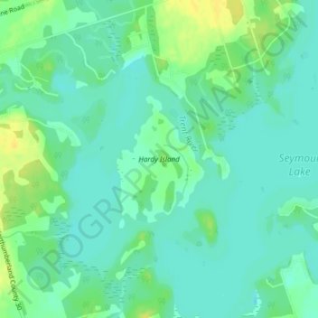
Name: Topografische Karte Hardy Island, Höhe, Relief.

Ort: Hardy Island, Trent Hills, Northumberland County, Central Ontario, Ontario, Canada (44.38202 -77.85477 44.39282 -77.84432)

Durchschnittliche Höhe: 187 m

Minimale Höhe: 179 m

Maximale Höhe: 202 m

👉 Easily get elevation data in JSON, GeoTIFF and KML formats using Elevation API
Vielen Dank für die Unterstützung dieser Website ❤️
Spenden

Andere topografische Karten

Klicken Sie auf eine Karte, um ihre Topografie, ihre Höhe und ihr Relief anzuzeigen.

Pethericks Corners

Canada > Ontario > Northumberland County > Trent Hills

Durchschnittliche Höhe: 181 m

Campbellford

Canada > Ontario > Northumberland County > Trent Hills

Durchschnittliche Höhe: 174 m

Warkworth

Canada > Ontario > Northumberland County > Trent Hills

Durchschnittliche Höhe: 165 m

Hastings

Canada > Ontario > Northumberland County > Trent Hills

Durchschnittliche Höhe: 207 m

Vielen Dank für die Unterstützung dieser Website ❤️
Spenden

Rylestone Lake

Canada > Ontario > Northumberland County > Trent Hills

Durchschnittliche Höhe: 187 m

Percy Boom

Canada > Ontario > Northumberland County > Trent Hills

Durchschnittliche Höhe: 127 m