
Topografische Karte Camelback Mountain
Interaktive Karte
Klicken Sie auf die Karte, um die Höhe anzuzeigen.
Camelback Mountain
Efforts to protect Camelback Mountain as a natural preserve began in the early 1910s. However, by the 1960s, nearly all of the area had been sold to private interests. Federal and state authorities attempted to stop development above the one thousand and six hundred feet level. They failed to halt development and in 1963 efforts to arrange a land exchange failed in the Arizona State legislature. In 1965, United States Senator Barry Goldwater took up the cause and helped to secure the higher elevations against development. The area became a Phoenix city park in 1968.
Über diese Karte
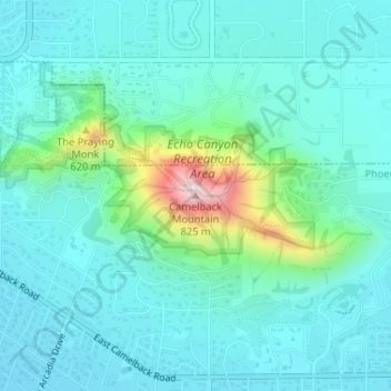
Name: Topografische Karte Camelback Mountain, Höhe, Relief.
Durchschnittliche Höhe: 462 m
Minimale Höhe: 389 m
Maximale Höhe: 798 m
Andere topografische Karten
Klicken Sie auf eine Karte, um ihre Topografie, ihre Höhe und ihr Relief anzuzeigen.