
Topografische Karte New River
Interaktive Karte
Klicken Sie auf die Karte, um die Höhe anzuzeigen.
Über diese Karte
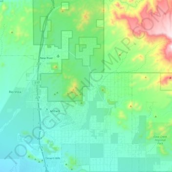
Name: Topografische Karte New River, Höhe, Relief.
Durchschnittliche Höhe: 690 m
Minimale Höhe: 483 m
Maximale Höhe: 1.417 m
Andere topografische Karten
Klicken Sie auf eine Karte, um ihre Topografie, ihre Höhe und ihr Relief anzuzeigen.
Prescott
United States of America > Arizona > Prescott
Prescott, Yavapai County, Arizona, United States of America
Durchschnittliche Höhe: 1.674 m
Gilbert
United States of America > Arizona > Gilbert
Gilbert, Maricopa County, Arizona, 85269, United States of America
Durchschnittliche Höhe: 400 m
Citrus Park
United States of America > Arizona > Citrus Park
Citrus Park, North 183rd Avenue, Citrus Park, Maricopa County, Arizona, 85355, United States of America
Durchschnittliche Höhe: 349 m
Camp Verde
United States of America > Arizona > Camp Verde
Camp Verde, Yavapai County, Arizona, United States of America
Durchschnittliche Höhe: 1.095 m
Ajo
United States of America > Arizona > Ajo
Ajo, Pima County, Arizona, 85321, United States of America
Durchschnittliche Höhe: 547 m
Bullhead City
United States of America > Arizona > Bullhead City
Bullhead City, Mohave County, Arizona, United States of America
Durchschnittliche Höhe: 322 m
Window Mountain
United States of America > Arizona
Window Mountain, Pima County, Arizona, United States of America
Durchschnittliche Höhe: 718 m
Shonto
United States of America > Arizona > Shonto
Shonto, Navajo Route 221, Shonto, Navajo County, Arizona, United States of America
Durchschnittliche Höhe: 1.963 m