
Topografische Karte Jiuzhaigou
Interaktive Karte
Klicken Sie auf die Karte, um die Höhe anzuzeigen.
Über diese Karte
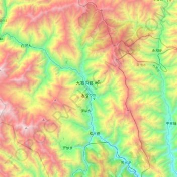
Name: Topografische Karte Jiuzhaigou, Höhe, Relief.
Durchschnittliche Höhe: 2.520 m
Minimale Höhe: 1.182 m
Maximale Höhe: 4.352 m
The county consists of nine villages in a valley in Sichuan Province. The main ethnic group in the county is Han, with the second being Tibetan. The county seat has an altitude of about 1,400 m (4,600 ft).[1] It has a total area of 2,041 square miles (5,286 km2).[2] As of 2015, the county's total population was 67,519.[2]
Andere topografische Karten
Klicken Sie auf eine Karte, um ihre Topografie, ihre Höhe und ihr Relief anzuzeigen.
Heye
China > Sichuan > Jiuzhaigou County
Heye, Jiuzhaigou County, Ngawa Tibetan and Qiang Autonomous Prefecture, Sichuan, 623400, China
Durchschnittliche Höhe: 2.598 m
Jiuzhai Valley National Park
China > Sichuan > Jiuzhaigou County
Jiuzhai Valley National Park, Jiuzhaigou County, Ngawa Tibetan and Qiang Autonomous Prefecture, Sichuan, 623402, China
Durchschnittliche Höhe: 3.424 m