
Topografische Karte Jiuzhai Valley National Park
Interaktive Karte
Klicken Sie auf die Karte, um die Höhe anzuzeigen.
Jiuzhai Valley National Park
The Jiuzhaigou valley is part of the Min Mountains on the edge of the Tibetan Plateau and stretches over 72,000 hectares (180,000 acres). It is known for its many multi-level waterfalls, colorful lakes, and snow-capped peaks. Its elevation ranges from 2,000 to 4,500 metres (6,600 to 14,800 ft).
Über diese Karte
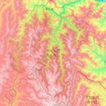
Name: Topografische Karte Jiuzhai Valley National Park, Höhe, Relief.
Durchschnittliche Höhe: 3.424 m
Minimale Höhe: 1.554 m
Maximale Höhe: 4.859 m
Andere topografische Karten
Klicken Sie auf eine Karte, um ihre Topografie, ihre Höhe und ihr Relief anzuzeigen.
Jiuzhaigou
China > Sichuan > Jiuzhaigou County
The county consists of nine villages in a valley in Sichuan Province. The main ethnic group in the county is Han, with the second being Tibetan. The county seat has an altitude of about 1,400 m (4,600 ft).[1] It has a total area of 2,041 square miles (5,286 km2).[2] As of 2015, the county's total population…
Durchschnittliche Höhe: 2.520 m