
Topografische Karte Donsol
Klicken Sie auf die Karte, um die Höhe anzuzeigen.
Über diese Karte
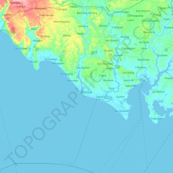
Name: Topografische Karte Donsol, Höhe, Relief.
Ort: Donsol, Sorsogon, Bicol Region, 4715, Philippines (12.80917 123.40830 13.02609 123.64627)
Durchschnittliche Höhe: 20 m
Minimale Höhe: -2 m
Maximale Höhe: 181 m
Andere topografische Karten
Klicken Sie auf eine Karte, um ihre Topografie, ihre Höhe und ihr Relief anzuzeigen.
Sorsogon City
Sorsogon City covers a land area of 31,292 hectares (120.82 sq mi). It is at the southernmost tip of the Bicol Peninsula and of Luzon Island. The city is bounded by Castilla in the west, Manito in the northwest, Albay Gulf in the north, Prieto Diaz in the east, Gubat in the southeast, Casiguran in the…
Durchschnittliche Höhe: 89 m
Bulusan Lake
Philippines > Sorsogon > San Roque
Lake Bulusan is a lake on Luzon Island in the Philippines. It lies at the heart of Bulusan Volcano National Park which covers a land area of 3,672 hectares (9,070 acres). It has an elevation of 360 metres (1,180 ft) and is located on the southeast flank of Mount Bulusan, an active volcano.
Durchschnittliche Höhe: 382 m
Pocdol Mountains
Philippines > Sorsogon > Castilla
There are several peaks above 1000 metres in elevation. The highest point is reported as 1,102 metres (3,615 ft) above sea level.
Durchschnittliche Höhe: 46 m