
Topografische Karte Uffington
Klicken Sie auf die Karte, um die Höhe anzuzeigen.
Über diese Karte
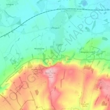
Name: Topografische Karte Uffington, Höhe, Relief.
Durchschnittliche Höhe: 138 m
Minimale Höhe: 70 m
Maximale Höhe: 261 m
Andere topografische Karten
Klicken Sie auf eine Karte, um ihre Topografie, ihre Höhe und ihr Relief anzuzeigen.
Boars Hill
United Kingdom > England > Oxfordshire > Vale of White Horse > Wootton
Durchschnittliche Höhe: 106 m
Lamborough Hill
United Kingdom > England > Oxfordshire > Vale of White Horse > Wootton
Durchschnittliche Höhe: 92 m
The Spinney
United Kingdom > England > Oxfordshire > Vale of White Horse > Kingston Bagpuize
Durchschnittliche Höhe: 77 m
Kingston Bagpuize
United Kingdom > England > Oxfordshire > Vale of White Horse
Durchschnittliche Höhe: 76 m
Carswell Marsh
United Kingdom > England > Oxfordshire > Vale of White Horse > Buckland
Durchschnittliche Höhe: 80 m
Dry Sandford
United Kingdom > England > Oxfordshire > Vale of White Horse
Durchschnittliche Höhe: 89 m
Sutton Pools
United Kingdom > England > Oxfordshire > Vale of White Horse > Abingdon > Sutton Courtenay
Durchschnittliche Höhe: 54 m
Sutton Wick
United Kingdom > England > Oxfordshire > Vale of White Horse > Abingdon > Drayton
Durchschnittliche Höhe: 57 m
Little Lews
United Kingdom > England > Oxfordshire > Vale of White Horse > Ardington
Durchschnittliche Höhe: 183 m
South Hinksey
United Kingdom > England > Oxfordshire > Vale of White Horse
Durchschnittliche Höhe: 79 m
White Horse Hill
United Kingdom > England > Oxfordshire > Vale of White Horse
Durchschnittliche Höhe: 184 m
Hackpen Hill
United Kingdom > England > Oxfordshire > Vale of White Horse
Durchschnittliche Höhe: 185 m
Badger's Well
United Kingdom > England > Oxfordshire > Vale of White Horse > Appleton
Durchschnittliche Höhe: 79 m
Milton Heights
United Kingdom > England > Oxfordshire > Vale of White Horse > Milton
Durchschnittliche Höhe: 72 m