
Topografische Karte Henwood
Klicken Sie auf die Karte, um die Höhe anzuzeigen.
Über diese Karte
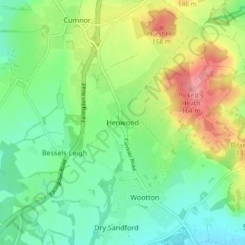
Name: Topografische Karte Henwood, Höhe, Relief.
Durchschnittliche Höhe: 108 m
Minimale Höhe: 74 m
Maximale Höhe: 170 m
Andere topografische Karten
Klicken Sie auf eine Karte, um ihre Topografie, ihre Höhe und ihr Relief anzuzeigen.
The Spinney
United Kingdom > England > Oxfordshire > Vale of White Horse > Kingston Bagpuize
Durchschnittliche Höhe: 77 m
Appleford-on-Thames
United Kingdom > England > Oxfordshire > Vale of White Horse
Durchschnittliche Höhe: 51 m
Ashdown Park
United Kingdom > England > Oxfordshire > Vale of White Horse > Ashbury
Durchschnittliche Höhe: 185 m
Letcombe Bassett
United Kingdom > England > Oxfordshire > Vale of White Horse
Durchschnittliche Höhe: 177 m
Wytham Woods
United Kingdom > England > Oxfordshire > Vale of White Horse > Farmoor
Durchschnittliche Höhe: 84 m
West Hendred
United Kingdom > England > Oxfordshire > Vale of White Horse
Durchschnittliche Höhe: 121 m
Stanford in the Vale
United Kingdom > England > Oxfordshire > Vale of White Horse
Durchschnittliche Höhe: 79 m
Hinton Waldrist
United Kingdom > England > Oxfordshire > Vale of White Horse
Durchschnittliche Höhe: 76 m
Sutton Courtenay
United Kingdom > England > Oxfordshire > Vale of White Horse
Durchschnittliche Höhe: 56 m
Letcombe Regis
United Kingdom > England > Oxfordshire > Vale of White Horse > Letcombe Regis
Durchschnittliche Höhe: 167 m
Botley and North Hinksey
United Kingdom > England > Oxfordshire > Vale of White Horse
Durchschnittliche Höhe: 78 m
Radley
United Kingdom > England > Oxfordshire > Vale of White Horse > Abingdon
Durchschnittliche Höhe: 66 m
East Challow
United Kingdom > England > Oxfordshire > Vale of White Horse
Durchschnittliche Höhe: 88 m
Great Coxwell
United Kingdom > England > Oxfordshire > Vale of White Horse > Faringdon
Durchschnittliche Höhe: 108 m
South Hinksey
United Kingdom > England > Oxfordshire > Vale of White Horse
Durchschnittliche Höhe: 83 m
East Hendred
United Kingdom > England > Oxfordshire > Vale of White Horse
Durchschnittliche Höhe: 119 m
Farmoor Reservoir
United Kingdom > England > Oxfordshire > Vale of White Horse > Cumnor
Durchschnittliche Höhe: 69 m
Besselsleigh
United Kingdom > England > Oxfordshire > Vale of White Horse
Durchschnittliche Höhe: 94 m
Little Lews
United Kingdom > England > Oxfordshire > Vale of White Horse > Ardington
Durchschnittliche Höhe: 183 m
Little Coxwell
United Kingdom > England > Oxfordshire > Vale of White Horse
Durchschnittliche Höhe: 111 m
Compton Beauchamp
United Kingdom > England > Oxfordshire > Vale of White Horse
Durchschnittliche Höhe: 142 m
Sunningwell
United Kingdom > England > Oxfordshire > Vale of White Horse > Abingdon
Durchschnittliche Höhe: 96 m
Kingston Lisle
United Kingdom > England > Oxfordshire > Vale of White Horse
Durchschnittliche Höhe: 145 m
Shellingford
United Kingdom > England > Oxfordshire > Vale of White Horse
Durchschnittliche Höhe: 85 m
West Challow
United Kingdom > England > Oxfordshire > Vale of White Horse > West Challow
Durchschnittliche Höhe: 90 m
Botley and North Hinksey
United Kingdom > England > Oxfordshire > Vale of White Horse
Durchschnittliche Höhe: 78 m
Stanford in the Vale
United Kingdom > England > Oxfordshire > Vale of White Horse
Durchschnittliche Höhe: 80 m