
Spenden
Topografische Karte Taal Crater Lake
Klicken Sie auf die Karte, um die Höhe anzuzeigen.
Spenden
Über diese Karte
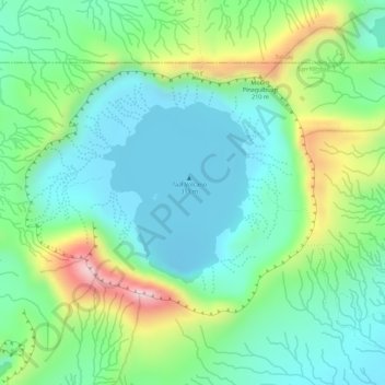
Name: Topografische Karte Taal Crater Lake, Höhe, Relief.
Durchschnittliche Höhe: 90 m
Minimale Höhe: -6 m
Maximale Höhe: 281 m
Spenden
Andere topografische Karten
Klicken Sie auf eine Karte, um ihre Topografie, ihre Höhe und ihr Relief anzuzeigen.
Taal Volcano
Philippines > Batangas > San Nicolas
Volcano Island sank from 1 to 3 m (3 to 10 ft) as a result of the eruption. It was also found that the southern shore of Lake Taal sank in elevation from the eruption. No evidences of lava could be discovered anywhere, nor have geologists been able to trace any visible records of a lava flow having occurred at…
Durchschnittliche Höhe: 91 m
Spenden
Taal Volcano
Philippines > Batangas > San Nicolas
The Tadlac Cave Formation is identified at two places along the southern shore of Lake Taal, which represents the southern part of Taal's caldera wall. Its type locality is Tadlac cave, about 2 km NNW of the Parish Church and public market in Alitagtag. The formation has a maximum exposed thickness of 21.7 m,…
Durchschnittliche Höhe: 91 m
Taal Volcano
Philippines > Batangas > San Nicolas
Volcano Island sank from 1 to 3 m (3 to 10 ft) as a result of the eruption. It was also found that the southern shore of Lake Taal sank in elevation from the eruption. No evidences of lava could be discovered anywhere, nor have geologists been able to trace any visible records of a lava flow having occurred at…
Durchschnittliche Höhe: 91 m