
Spenden
Topografische Karte Taal Volcano
Klicken Sie auf die Karte, um die Höhe anzuzeigen.
Spenden
Taal Volcano
The Tadlac Cave Formation is identified at two places along the southern shore of Lake Taal, which represents the southern part of Taal's caldera wall. Its type locality is Tadlac cave, about 2 km NNW of the Parish Church and public market in Alitagtag. The formation has a maximum exposed thickness of 21.7 m, but its base and top contacts are not exposed. Its low elevation, dropping into the lake, and the thick vegetation cover where not eroded suggests it is one of Taal's prehistoric eruption-units, other examples of which have been found in the cliffs on the south coast of the lake. A lack of exposure on the ignimbrite plains suggests the formation is covered by material from more recent eruptions, including the Indang and Pasong eruptions. It is not clear from field relations whether it is younger than the 'Caloocan Formation' identified in previous work and no absolute age is yet to be determined. The Tadlac Cave Formation provides evidence of an ignimbrite producing, likely caldera-forming eruption because it contains a proximal lithic breccia and has a volume estimation of 17 km3, sufficient for caldera formation.
Spenden
Über diese Karte
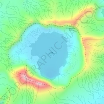
Name: Topografische Karte Taal Volcano, Höhe, Relief.
Durchschnittliche Höhe: 91 m
Minimale Höhe: -6 m
Maximale Höhe: 281 m
Spenden
Andere topografische Karten
Klicken Sie auf eine Karte, um ihre Topografie, ihre Höhe und ihr Relief anzuzeigen.