
Spenden
Topografische Karte La Daille
Klicken Sie auf die Karte, um die Höhe anzuzeigen.
Spenden
Über diese Karte
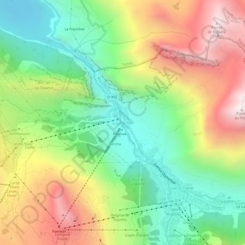
Name: Topografische Karte La Daille, Höhe, Relief.
Durchschnittliche Höhe: 2.218 m
Minimale Höhe: 1.694 m
Maximale Höhe: 2.944 m
Spenden
Andere topografische Karten
Klicken Sie auf eine Karte, um ihre Topografie, ihre Höhe und ihr Relief anzuzeigen.
Spenden
Saint-Jean-de-Belleville
France > Auvergne-Rhône-Alpes > Savoy > Les Belleville
Durchschnittliche Höhe: 1.806 m
Tignes
France > Auvergne-Rhône-Alpes > Savoy
The terrain of valley lends itself to more challenging skiing, with advanced skiers often opting for the resort as their preferred ski area. The town has however strived to improve its appeal to beginner and intermediate skiers with the introduction of easier runs lower down in the valley towards…
Durchschnittliche Höhe: 2.520 m
Spenden
Barrage de Roselend
France > Auvergne-Rhône-Alpes > Savoy > Beaufort
The dam has a maximum height of 150 m (492 ft) and a length of 804 m (2,638 ft). It is 3 m (10 ft) wide at its crest and 22 m (72 ft) wide at its base. The dam has a structural volume of 945,000 m3 (1,236,013 cu yd). Its reservoir, Lac de Roselend, can store 187,000,000 m3 (151,603 acre⋅ft) of water and has…
Durchschnittliche Höhe: 1.598 m
Spenden
Albertville
France > Auvergne-Rhône-Alpes > Savoy
Albertville is situated on the river Arly, close to the confluence with the river Isère. Its altitude ranges from 345 to 2,037 metres (1,132 to 6,683 ft). Nearby mountains include: Belle Étoile, Dent de Cons, Négresse, Roche Pourrie, Mirantin, Pointe de la Grande Journée, Chaîne du Grand Arc. Nearby…
Durchschnittliche Höhe: 595 m
Spenden
Lac du Mont-Cenis
France > Auvergne-Rhône-Alpes > Savoy > Val-Cenis
Mont-Cenis Lake is a lake located in the Mont-Cenis massif at an altitude of 1,974 meters (6,476 ft) in the municipality of Val-Cenis in France. It is situated at the top of the Cenise valley, on the Italian side of the Mont-Cenis pass, the most frequented passage on the Lyon-Turin-Milan axis during the Middle…
Durchschnittliche Höhe: 2.096 m
Rocher de Minecraft
France > Auvergne-Rhône-Alpes > Savoy > La Giettaz
Durchschnittliche Höhe: 1.851 m
Spenden
Lac du Bourget
France > Auvergne-Rhône-Alpes > Savoy > Brison-Saint-Innocent
Durchschnittliche Höhe: 445 m
Glacier de la Grande Casse
France > Auvergne-Rhône-Alpes > Savoy > Pralognan-la-Vanoise
Durchschnittliche Höhe: 2.896 m
Spenden
Spenden
Modane
France > Auvergne-Rhône-Alpes > Savoy
In 1969, the city turned to tourism. A chairlift departing from Fourneaux and joining the hamlet of Charmaix on the commune of Modane, at 1,550 metres (5,090 ft) altitude, was indeed created, like the d'Arrondaz snow stadium, allowing skiing at 1,550 to 2,500 metres (5,090 to 8,200 ft) altitude.
Durchschnittliche Höhe: 2.241 m
Spenden
Saint-Sorlin-d'Arves
France > Auvergne-Rhône-Alpes > Savoy
It is a ski resort, part of the larger Les Sybelles area. Gaston Maulin's project of linking St Sorlin with the La Toussuire and Le Corbier ski resorts has created Les Sybelles, an area that ranks high in the list of the largest French ski areas, with over 300 kilometres of intermediate level skiing. The St…
Durchschnittliche Höhe: 1.998 m
Spenden
Tignes
France > Auvergne-Rhône-Alpes > Savoy
The terrain of valley lends itself to more challenging skiing, with advanced skiers often opting for the resort as their preferred ski area. The town has however strived to improve its appeal to beginner and intermediate skiers with the introduction of easier runs lower down in the valley towards…
Durchschnittliche Höhe: 2.520 m
Les Sybelles
France > Auvergne-Rhône-Alpes > Savoy > Fontcouverte-la-Toussuire
Durchschnittliche Höhe: 1.732 m
Albertville
France > Auvergne-Rhône-Alpes > Savoy
Albertville is situated on the river Arly, close to the confluence with the river Isère. Its altitude ranges from 345 to 2,037 metres (1,132 to 6,683 ft). Nearby mountains include: Belle Étoile, Dent de Cons, Négresse, Roche Pourrie, Mirantin, Pointe de la Grande Journée, Chaîne du Grand Arc. Nearby…
Durchschnittliche Höhe: 595 m
Spenden
Lac du Grand Méan
France > Auvergne-Rhône-Alpes > Savoy > Bonneval-sur-Arc
Durchschnittliche Höhe: 2.821 m
73210
France > Auvergne-Rhône-Alpes > Savoy > La Plagne-Tarentaise > Sangot
Durchschnittliche Höhe: 1.766 m
Spenden
Saint-Jean-de-Belleville
France > Auvergne-Rhône-Alpes > Savoy > Les Belleville
Durchschnittliche Höhe: 1.806 m
Bessans
France > Auvergne-Rhône-Alpes > Savoy
Located on the Haute-Maurienne plateau, at an altitude of 1750 meters, the area is known for its sporting activities. Bessans is located in a valley, ideal for Nordic skiing. Following the collapse of the mountain downstream from Bessans (between 10000 and 3000 years BC), an ice-dammed lake formed. The…
Durchschnittliche Höhe: 2.532 m
Spenden
Glacier de la Roche Noire
France > Auvergne-Rhône-Alpes > Savoy > Orelle
Durchschnittliche Höhe: 2.651 m
Spenden
Spenden
Spenden
73700
France > Auvergne-Rhône-Alpes > Savoy > Bourg-Saint-Maurice > Versoye-les-Granges
Durchschnittliche Höhe: 1.999 m
Albertville
France > Auvergne-Rhône-Alpes > Savoy
Albertville is situated on the river Arly, close to the confluence with the river Isère. Its altitude ranges from 345 to 2,037 metres (1,132 to 6,683 ft). Nearby mountains include: Belle Étoile, Dent de Cons, Négresse, Roche Pourrie, Mirantin, Pointe de la Grande Journée, Chaîne du Grand Arc. Nearby…
Durchschnittliche Höhe: 595 m
Spenden
73700
France > Auvergne-Rhône-Alpes > Savoy > Bourg-Saint-Maurice > Versoye-les-Granges
Durchschnittliche Höhe: 1.999 m
Spenden
Communauté de communes de Haute Tarentaise
France > Auvergne-Rhône-Alpes > Savoy
Durchschnittliche Höhe: 2.188 m
Modane
France > Auvergne-Rhône-Alpes > Savoy
In 1969, the city turned to tourism. A chairlift departing from Fourneaux and joining the hamlet of Charmaix on the commune of Modane, at 1,550 metres (5,090 ft) altitude, was indeed created, like the d'Arrondaz snow stadium, allowing skiing at 1,550 to 2,500 metres (5,090 to 8,200 ft) altitude.
Durchschnittliche Höhe: 2.241 m
Spenden
Aix-les-Bains
France > Auvergne-Rhône-Alpes > Savoy
Aix-les-Bains is located in the southeast of France, 107 kilometres (66 mi) east of Lyon. The town is located in a corridor between the mountain of Mont Revard, the first natural rampart of the Massif des Bauges to the east and the Lac du Bourget, the largest natural lake of France to the west. Thus, the city…
Durchschnittliche Höhe: 348 m
Spenden
Spenden
Bonneval-sur-Arc
France > Auvergne-Rhône-Alpes > Savoy
Bonneval-sur-Arc features an alpine climate due to its high elevation, just under the tree line. Its climate is characterised by very cold, snowy winters and cool, stormy summers.
Durchschnittliche Höhe: 2.636 m
Spenden
Tignes
France > Auvergne-Rhône-Alpes > Savoy
The terrain of valley lends itself to more challenging skiing, with advanced skiers often opting for the resort as their preferred ski area. The town has however strived to improve its appeal to beginner and intermediate skiers with the introduction of easier runs lower down in the valley towards…
Durchschnittliche Höhe: 2.520 m
Spenden
Modane
France > Auvergne-Rhône-Alpes > Savoy
In 1969, the city turned to tourism. A chairlift departing from Fourneaux and joining the hamlet of Charmaix on the commune of Modane, at 1,550 metres (5,090 ft) altitude, was indeed created, like the d'Arrondaz snow stadium, allowing skiing at 1,550 to 2,500 metres (5,090 to 8,200 ft) altitude.
Durchschnittliche Höhe: 2.241 m
Saint-Sorlin-d'Arves
France > Auvergne-Rhône-Alpes > Savoy
It is a ski resort, part of the larger Les Sybelles area. Gaston Maulin's project of linking St Sorlin with the La Toussuire and Le Corbier ski resorts has created Les Sybelles, an area that ranks high in the list of the largest French ski areas, with over 300 kilometres of intermediate level skiing. The St…
Durchschnittliche Höhe: 1.998 m
Spenden
Spenden