
Topografische Karte Saint-Sorlin-d'Arves
Interaktive Karte
Klicken Sie auf die Karte, um die Höhe anzuzeigen.
Saint-Sorlin-d'Arves
It is a ski resort, part of the larger Les Sybelles area. Gaston Maulin's project of linking St Sorlin with the La Toussuire and Le Corbier ski resorts has created Les Sybelles, an area that ranks high in the list of the largest French ski areas, with over 300 kilometres of intermediate level skiing. The St Sorlin area has over 120 kilometres of pistes and is generally considered to have the best runs and be the best placed sector of the Sybelles area. With village slopes starting at 1550 metres and a current maximum lift altitude of 2620 metres there is normally good snow until the end of April but there are also plenty of strategically placed snow cannons. St Sorlin has a 16 km cross country ski trails, 4 green, 11 blue, 9 red and 2 black runs with beginners slopes in the village.
Über diese Karte
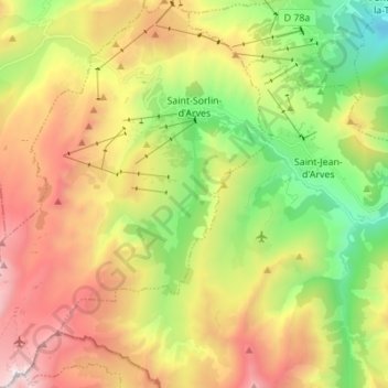
Name: Topografische Karte Saint-Sorlin-d'Arves, Höhe, Relief.
Durchschnittliche Höhe: 1.998 m
Minimale Höhe: 1.033 m
Maximale Höhe: 3.210 m
Andere topografische Karten
Klicken Sie auf eine Karte, um ihre Topografie, ihre Höhe und ihr Relief anzuzeigen.
Le Chapet
France > Auvergne-Rhône-Alpes > Savoy > La Giettaz > La Giettaz-en-Aravis
Durchschnittliche Höhe: 1.397 m
Pierre Martine
France > Auvergne-Rhône-Alpes > Savoy > Ugine > Outrechaise
Durchschnittliche Höhe: 689 m
Glacier de la Grande Casse
France > Auvergne-Rhône-Alpes > Savoy > Pralognan-la-Vanoise
Durchschnittliche Höhe: 2.896 m
Lac du Grand Méan
France > Auvergne-Rhône-Alpes > Savoy > Bonneval-sur-Arc
Durchschnittliche Höhe: 2.821 m
Villard-Bernon
France > Auvergne-Rhône-Alpes > Savoy > Saint-Michel-de-Maurienne
Durchschnittliche Höhe: 1.155 m
Villarabout
France > Auvergne-Rhône-Alpes > Savoy > Saint-Martin-de-Belleville
Durchschnittliche Höhe: 1.600 m
Val Thorens
France > Auvergne-Rhône-Alpes > Savoy
Val Thorens ([val tɔʁɑ̃]) is a ski town in the Tarentaise Valley in the French Alps at an altitude of 2,300 m (7,500 ft). It is located in the commune of Saint-Martin-de-Belleville in the Savoie department. The resort forms part of the Les Trois Vallées ski area which, with over 600 km of slopes, is one…
Durchschnittliche Höhe: 2.516 m
Crête Côte
France > Auvergne-Rhône-Alpes > Savoy > La Plagne-Tarentaise
Durchschnittliche Höhe: 1.861 m
Montalbert
France > Auvergne-Rhône-Alpes > Savoy > Sainte-Foy-Tarentaise
Durchschnittliche Höhe: 1.601 m
Aiguille Centrale d'Arves
France > Auvergne-Rhône-Alpes > Savoy > Valloire
Durchschnittliche Höhe: 2.804 m
Praranger
France > Auvergne-Rhône-Alpes > Savoy > Saint-Martin-de-Belleville
Durchschnittliche Höhe: 1.867 m
Plagne Villages
France > Auvergne-Rhône-Alpes > Savoy > La Plagne-Tarentaise
Durchschnittliche Höhe: 2.104 m
Les Ménuires
France > Auvergne-Rhône-Alpes > Savoy
The resort was founded in 1964 and has an altitude range of 1,850 m (6,070 ft).
Durchschnittliche Höhe: 2.063 m
Rocher de Minecraft
France > Auvergne-Rhône-Alpes > Savoy > La Giettaz
Durchschnittliche Höhe: 1.851 m
Le Chantel
France > Auvergne-Rhône-Alpes > Savoy > Bourg-Saint-Maurice > Arc 1800
Durchschnittliche Höhe: 1.770 m
Les Fontanettes
France > Auvergne-Rhône-Alpes > Savoy > Saint-Martin-de-Belleville
Durchschnittliche Höhe: 2.085 m
Val Thorens
France > Auvergne-Rhône-Alpes > Savoy
Val Thorens ([val tɔʁɑ̃]) is a ski town in the Tarentaise Valley in the French Alps at an altitude of 2,300 m (7,500 ft). It is located in the commune of Saint-Martin-de-Belleville in the Savoie department. The resort forms part of the Les Trois Vallées ski area which, with over 600 km of slopes, is one…
Durchschnittliche Höhe: 2.516 m
Le Villaret
France > Auvergne-Rhône-Alpes > Savoy > Bourg-Saint-Maurice
Durchschnittliche Höhe: 1.119 m
Col de l'Iseran
France > Auvergne-Rhône-Alpes > Savoy > Bonneval-sur-Arc
On both sides of the Col de l'Iseran, mountain pass cycling milestones mark the distance to the summit, the current altitude, and the average slope in the following kilometre.
Durchschnittliche Höhe: 2.779 m
Puy Gris
France > Auvergne-Rhône-Alpes > Savoy > Saint-Colomban-des-Villards
Durchschnittliche Höhe: 2.469 m
Le Grand Morétan
France > Auvergne-Rhône-Alpes > Savoy > Saint-Colomban-des-Villards
Durchschnittliche Höhe: 2.307 m
Saint-Jean-de-Maurienne
France > Auvergne-Rhône-Alpes > Savoy > Saint-Jean-de-Maurienne > Saint-Jean-de-Maurienne
Durchschnittliche Höhe: 1.089 m
Montchavin
France > Auvergne-Rhône-Alpes > Savoy > La Plagne-Tarentaise
Durchschnittliche Höhe: 1.196 m
Plagne Centre
France > Auvergne-Rhône-Alpes > Savoy > La Plagne-Tarentaise > Plagne Centre
Durchschnittliche Höhe: 2.078 m
La Toussuire
France > Auvergne-Rhône-Alpes > Savoy > Fontcouverte-la-Toussuire
Durchschnittliche Höhe: 1.710 m
Lac supérieur de Rhêmes-Golette
France > Auvergne-Rhône-Alpes > Savoy > Tignes
Durchschnittliche Höhe: 3.047 m
Le Grand Couloir
France > Auvergne-Rhône-Alpes > Savoy > Pralognan-la-Vanoise > Le Grand Couloir
Durchschnittliche Höhe: 1.876 m
Les Coches
France > Auvergne-Rhône-Alpes > Savoy > La Plagne-Tarentaise
Durchschnittliche Höhe: 1.301 m
Val Thorens
France > Auvergne-Rhône-Alpes > Savoy
Val Thorens ([val tɔʁɑ̃]) is a ski town in the Tarentaise Valley in the French Alps at an altitude of 2,300 m (7,500 ft). It is located in the commune of Saint-Martin-de-Belleville in the Savoie department. The resort forms part of the Les Trois Vallées ski area which, with over 600 km of slopes, is one…
Durchschnittliche Höhe: 2.516 m
Belle Plagne
France > Auvergne-Rhône-Alpes > Savoy > La Plagne-Tarentaise
Durchschnittliche Höhe: 2.204 m
Plagne Montalbert
France > Auvergne-Rhône-Alpes > Savoy > Aime-la-Plagne > Plagne Montalbert
Durchschnittliche Höhe: 1.188 m