
Spenden
Topografische Karte Marchena Island
Klicken Sie auf die Karte, um die Höhe anzuzeigen.
Spenden
Über diese Karte
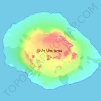
Name: Topografische Karte Marchena Island, Höhe, Relief.
Ort: Marchena Island, Cantón Santa Cruz, Galápagos, Ecuador (0.27666 -90.54267 0.38680 -90.40060)
Durchschnittliche Höhe: 51 m
Minimale Höhe: -1 m
Maximale Höhe: 335 m
Spenden
Andere topografische Karten
Klicken Sie auf eine Karte, um ihre Topografie, ihre Höhe und ihr Relief anzuzeigen.
Isla Santa Cruz
Ecuador > Galápagos > Cantón Santa Cruz
Santa Cruz Island (Spanish: Isla Santa Cruz), also known as Indefatigable Island and by other names, is the most populous and second-largest island in the Galápagos Islands, Ecuador. Situated in the middle of the group, Santa Cruz is a shield volcano with an area of 986 km2 (381 sq mi) and a maximum altitude…
Durchschnittliche Höhe: 95 m
Marchena Island
Ecuador > Galápagos > Cantón Santa Cruz
Marchena Island (Spanish: Isla Marchena) is one of the Galapagos Islands in Ecuador. It has an area of 130 square kilometers (50 sq mi) and reaches an elevation of 343 meters (1,125 ft) above sea level. The island does not receive visitors, although the surrounding water is used by aquatic divers on organized…
Durchschnittliche Höhe: 50 m
Spenden
Isla Santa Cruz
Ecuador > Galápagos > Cantón Santa Cruz
Santa Cruz Island (Spanish pronunciation: [ˈsanta ˈkɾus]) is one of the Galápagos Islands with an area of 986 km2 (381 sq mi) and a maximum altitude of 864 metres (2,835 ft). Situated in the center of the archipelago, Santa Cruz is the second largest island after Isabela. Its capital is Puerto Ayora, the…
Durchschnittliche Höhe: 95 m
Spenden
Spenden
Isla Pinta
Ecuador > Galápagos > Cantón Santa Cruz
Pinta Island (Spanish: Isla Pinta) is one of the Galápagos Islands in Ecuador, west of South America. Pinta has an area of 60 km2 (23 sq mi) and a maximum altitude of 777 meters (2,549 ft).
Durchschnittliche Höhe: 77 m