
Spenden
Topografische Karte Isla Pinta
Klicken Sie auf die Karte, um die Höhe anzuzeigen.
Spenden
Isla Pinta
Pinta Island (Spanish: Isla Pinta) is one of the Galápagos Islands in Ecuador, west of South America. Pinta has an area of 60 km2 (23 sq mi) and a maximum altitude of 777 meters (2,549 ft).
Spenden
Über diese Karte
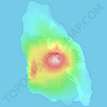
Name: Topografische Karte Isla Pinta, Höhe, Relief.
Durchschnittliche Höhe: 77 m
Minimale Höhe: -1 m
Maximale Höhe: 630 m
Spenden
Andere topografische Karten
Klicken Sie auf eine Karte, um ihre Topografie, ihre Höhe und ihr Relief anzuzeigen.
Isla Pinzón
Ecuador > Galápagos > Cantón Santa Cruz
Pinzón or Pinzon Island (Spanish: Isla Pinzón) is an island in Ecuador's Galápagos Archipelago. It has no permanent population, an area of 18 square kilometers (6.9 sq mi), and a maximum elevation of 458 meters (1,503 ft). Home to giant Galápagos tortoises of the subspecies Chelonoidis duncanensis and…
Durchschnittliche Höhe: 124 m
Spenden
Isla Plaza Sur
Ecuador > Galápagos > Cantón Santa Cruz
South Plaza (Spanish: Isla Plaza Sur) is a small island off the east coast of Santa Cruz in the Galápagos Islands. It has an area of 0.13 km2 and a maximum altitude of 23 metres.
Durchschnittliche Höhe: 5 m
Spenden