Geolokalisieren
👉 Easily get elevation data in JSON, GeoTIFF and KML formats using Elevation API
Vielen Dank für die Unterstützung dieser Website ❤️
Spenden

Topografische Karte La Feuillée

Klicken Sie auf die Karte, um die Höhe anzuzeigen.

👉 Easily get elevation data in JSON, GeoTIFF and KML formats using Elevation API
Vielen Dank für die Unterstützung dieser Website ❤️
Spenden

La Feuillée

The village is situated in the Monts d'Arrée, a moorland area in the northern part of the Finistère. The village centre is located 21 km (13 mi) south of Morlaix and 47 km (29 mi) east of Brest. The village centre is the highest in Brittany. It is at an altitude of 275 meters. It is surrounded by several high peaks : the Roc'h Trevezel (385 meters), the Roc'h Tredudon (385 meters).

Wikipedia (CC-BY-SA 3.0)

👉 Easily get elevation data in JSON, GeoTIFF and KML formats using Elevation API
Vielen Dank für die Unterstützung dieser Website ❤️
Spenden

Über diese Karte

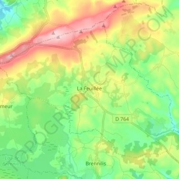
Name: Topografische Karte La Feuillée, Höhe, Relief.

Ort: La Feuillée, Châteaulin, Finistère, Brittany, Metropolitan France, 29690, France (48.36032 -3.91952 48.42190 -3.79762)

Durchschnittliche Höhe: 258 m

Minimale Höhe: 183 m

Maximale Höhe: 379 m

👉 Easily get elevation data in JSON, GeoTIFF and KML formats using Elevation API
Vielen Dank für die Unterstützung dieser Website ❤️
Spenden

Andere topografische Karten

Klicken Sie auf eine Karte, um ihre Topografie, ihre Höhe und ihr Relief anzuzeigen.

Kereven

France > Brittany > Finistère > Primel-Trégastel

Durchschnittliche Höhe: 21 m

Malakoff

France > Brittany > Finistère > Sainte-Marine

Durchschnittliche Höhe: 10 m

Kerivoas

France > Brittany > Finistère > Guipavas

Durchschnittliche Höhe: 73 m

Kerféos

France > Brittany > Finistère > Sizun > Kerfeonwez

Durchschnittliche Höhe: 164 m

Vielen Dank für die Unterstützung dieser Website ❤️
Spenden

Morgat

France > Brittany > Finistère

Durchschnittliche Höhe: 30 m

Lochrist

France > Brittany > Finistère

Durchschnittliche Höhe: 38 m

La Caserne

France > Brittany > Finistère > Aber-Wrac'h

Durchschnittliche Höhe: 22 m

Quéran

France > Brittany > Finistère > Tréflaouénan

Durchschnittliche Höhe: 70 m

Vielen Dank für die Unterstützung dieser Website ❤️
Spenden

Prad Don

France > Brittany > Finistère > Plomeur

Durchschnittliche Höhe: 26 m

Tregonnour

France > Brittany > Finistère > Fouesnant > Mousterlin

Durchschnittliche Höhe: 4 m

Run Ar Puns

France > Brittany > Finistère > Châteaulin

Durchschnittliche Höhe: 55 m

Vielen Dank für die Unterstützung dieser Website ❤️
Spenden

Ti-korn

France > Brittany > Finistère > Aber-Wrac'h

Durchschnittliche Höhe: 27 m

Braspart

France > Brittany > Finistère > Kervaziou

Durchschnittliche Höhe: 44 m

Keremma

France > Brittany > Finistère

Durchschnittliche Höhe: 10 m

Goarem ar Zant

France > Brittany > Finistère > Brest

Durchschnittliche Höhe: 78 m

Vielen Dank für die Unterstützung dieser Website ❤️
Spenden

Le Cabellou

France > Brittany > Finistère > Concarneau

Durchschnittliche Höhe: 7 m

Langue

France > Brittany > Finistère > Plouarzel

Durchschnittliche Höhe: 82 m

Les Carrières

France > Brittany > Finistère > Huelgoat

Durchschnittliche Höhe: 212 m

Kerbriant

France > Brittany > Finistère > Le Folgoët

Durchschnittliche Höhe: 63 m

Vielen Dank für die Unterstützung dieser Website ❤️
Spenden

Keremma

France > Brittany > Finistère

Durchschnittliche Höhe: 10 m

Léchiagat

France > Brittany > Finistère

Durchschnittliche Höhe: 6 m

Port de Heign Has

France > Brittany > Finistère > Cléden-Cap-Sizun > Penharn

Durchschnittliche Höhe: 31 m

Eckmühl Lighthouse

France > Brittany > Finistère > Penmarc'h > Kerfezec

Durchschnittliche Höhe: 1 m

Vielen Dank für die Unterstützung dieser Website ❤️
Spenden

Moulin du Pont

France > Brittany > Finistère > Plabennec

Durchschnittliche Höhe: 73 m

Les Capucins

France > Brittany > Finistère > Audierne

Durchschnittliche Höhe: 31 m

Méchou Rouz

France > Brittany > Finistère > Santec

Durchschnittliche Höhe: 8 m

Vielen Dank für die Unterstützung dieser Website ❤️
Spenden

Isole

France > Brittany > Finistère > Bannalec

Durchschnittliche Höhe: 79 m

Cosquer

France > Brittany > Finistère > Saint-Thégonnec Loc-Eguiner > Cosquer

Durchschnittliche Höhe: 136 m

Rusquec

France > Brittany > Finistère > Loqueffret

Durchschnittliche Höhe: 195 m

Kerinou

France > Brittany > Finistère > Plogonnec > Kerinou

Durchschnittliche Höhe: 139 m

Vielen Dank für die Unterstützung dieser Website ❤️
Spenden

Odeveur

France > Brittany > Finistère > Kersaint-Plabennec > Odeveur

Durchschnittliche Höhe: 99 m

Moulin de Bel Air

France > Brittany > Finistère > Brélès > Moulin de Bel Air

Durchschnittliche Höhe: 40 m

Kergadalen

France > Brittany > Finistère > Rosnoën > Kergadalen

Durchschnittliche Höhe: 51 m

Beg-Meil

France > Brittany > Finistère > Fouesnant > Beg-Meil

Durchschnittliche Höhe: 7 m

Vielen Dank für die Unterstützung dieser Website ❤️
Spenden

Morgat

France > Brittany > Finistère

Durchschnittliche Höhe: 30 m

Marros

France > Brittany > Finistère > Argol

Durchschnittliche Höhe: 49 m

Kerouman

France > Brittany > Finistère > Ploumoguer

Durchschnittliche Höhe: 74 m

Scars

France > Brittany > Finistère > Névez

Durchschnittliche Höhe: 33 m

Vielen Dank für die Unterstützung dieser Website ❤️
Spenden

Le Kerou Village

France > Brittany > Finistère > Le Pouldu

Durchschnittliche Höhe: 22 m

Poul ar Groas

France > Brittany > Finistère > Brasparts

Durchschnittliche Höhe: 172 m

Coat Pin

France > Brittany > Finistère > Concarneau

Durchschnittliche Höhe: 12 m

Kergoalabre

France > Brittany > Finistère > Riec-sur-Bélon

Durchschnittliche Höhe: 47 m

Vielen Dank für die Unterstützung dieser Website ❤️
Spenden

Beniel

France > Brittany > Finistère > Pentrez

Durchschnittliche Höhe: 33 m

Bellangenet

France > Brittany > Finistère > Le Pouldu

Durchschnittliche Höhe: 15 m

Keravezan

France > Brittany > Finistère > Plounéour-Brignogan-Plages

Durchschnittliche Höhe: 6 m