
Spenden
Topografische Karte Lochrist
Klicken Sie auf die Karte, um die Höhe anzuzeigen.
Spenden
Über diese Karte
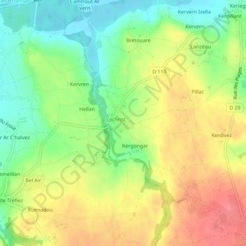
Name: Topografische Karte Lochrist, Höhe, Relief.
Durchschnittliche Höhe: 38 m
Minimale Höhe: 2 m
Maximale Höhe: 77 m
Spenden
Andere topografische Karten
Klicken Sie auf eine Karte, um ihre Topografie, ihre Höhe und ihr Relief anzuzeigen.
Spenden
Spenden
Spenden
Spenden
Spenden
Lotissement Le Clos de Kersioual
France > Brittany > Finistère > Port-la-Forêt
Durchschnittliche Höhe: 25 m
Spenden
Spenden
Spenden
La Feuillée
The village is situated in the Monts d'Arrée, a moorland area in the northern part of the Finistère. The village centre is located 21 km (13 mi) south of Morlaix and 47 km (29 mi) east of Brest. The village centre is the highest in Brittany. It is at an altitude of 275 meters. It is surrounded by several…
Durchschnittliche Höhe: 258 m
Spézet
Spézet is a rural municipality in east central Finistère, historically belonging to Cornouaille. It is bounded on the west and north by the river the Aulne and Hyères describing large meanders (Nantes-Brest Canal-channel) while at the southeast end of its territory lies Roc'h Toullaëron, which from its…
Durchschnittliche Höhe: 136 m
Spenden
Spenden
Spenden
Spenden
Spenden
Spenden
Spenden
Spenden
Port de Heign Has
France > Brittany > Finistère > Cléden-Cap-Sizun > Penharn
Durchschnittliche Höhe: 31 m
Spenden
Spenden
Carhaix-Plouguer
France > Brittany > Finistère > Carhaix-Plouguer
Carhaix is located in the Poher, an important territory of Brittany, sandwiched between the Arrée Mountains to the north and the Black Mountains to the south. The agglomeration developed mainly on a plateau located at 140 meters above sea level, gently sloping towards the west, the highest elevations being…
Durchschnittliche Höhe: 120 m
Spenden
Spenden
Spenden
Moulin de Bel Air
France > Brittany > Finistère > Brélès > Moulin de Bel Air
Durchschnittliche Höhe: 40 m
Spenden
Spenden
Spenden
Spenden