
Spenden
Topografische Karte Brejo Bonito
Klicken Sie auf die Karte, um die Höhe anzuzeigen.
Spenden
Über diese Karte
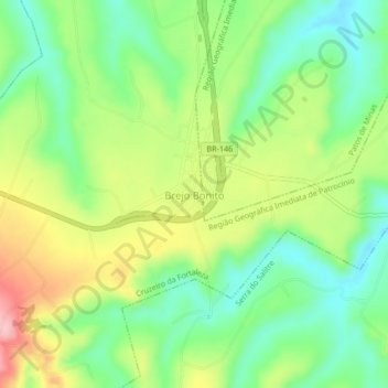
Name: Topografische Karte Brejo Bonito, Höhe, Relief.
Durchschnittliche Höhe: 918 m
Minimale Höhe: 856 m
Maximale Höhe: 1.010 m
Spenden
Andere topografische Karten
Klicken Sie auf eine Karte, um ihre Topografie, ihre Höhe und ihr Relief anzuzeigen.
Serra da Mantiqueira
Brazil > Minas Gerais > Passa Quatro
The Serra da Mantiqueira is a part of the Atlantic Forest ecosystem. Despite the clearing of the land for livestock raising, the difficult access to many areas has made possible for sanctuaries of well-preserved forest to still exist, with trees such as the jacarandá, Spanish cedar, canjerana, guatambu, ipê,…
Durchschnittliche Höhe: 2.271 m
Taiobeiras
Taiobeiras is a municipality in the north of the state of Minas Gerais in Brazil. As of 2020 the population was 34,397 in an area of 1,194 km2. The elevation of the municipal seat is 821 meters. It became a municipality in 1953. The postal code (CEP) is 39550-000 and it belongs to the statistical microregion…
Durchschnittliche Höhe: 793 m
Belo Horizonte
In 1893 due to the climatic and topographic conditions, Curral Del Rey was selected by Minas Gerais governor Afonso Pena among other cities as the location for the new economic and cultural center of the state, under the new name of Cidade de Minas, or City of Minas.
Durchschnittliche Höhe: 895 m
Spenden
Florestal
Brazil > Minas Gerais > Região Metropolitana de Belo Horizonte
Durchschnittliche Höhe: 810 m
Spenden
Brumadinho
Brumadinho (Brazilian Portuguese: [bɾumaˈdʒiɲu]) is a Brazilian municipality in the state of Minas Gerais. The city belongs to the Belo Horizonte metropolitan mesoregion and to the microregion of Belo Horizonte. Brumadinho is at an altitude of 880 m. In 2020 the population was 40,666. The municipality is…
Durchschnittliche Höhe: 889 m
Cabo Verde
The city center of Cabo Verde is located at an elevation of 927 meters a short distance from the state boundary of São Paulo. Neighboring municipalities are: Monte Belo (N), Areado (NE), Divisa Nova (E), Botelhos (S), Caconde (W) and Muzambinho (NW).
Durchschnittliche Höhe: 937 m
Betim
Brazil > Minas Gerais > Região Metropolitana de Belo Horizonte
Betim is located on the southwest of Belo Horizonte IGR, with Rio Paraopeba flowing through its south. Its average elevation is 830 meters above the sea level.
Durchschnittliche Höhe: 829 m
Spenden
Betim
Betim is located on the southwest of Belo Horizonte IGR, with Rio Paraopeba flowing through its south. Its average elevation is 830 meters above the sea level.
Durchschnittliche Höhe: 829 m
Belo Horizonte
Brazil > Minas Gerais > Região Metropolitana de Belo Horizonte
In 1893, due to the climatic and topographic conditions, Curral Del Rey was selected by Minas Gerais governor Afonso Pena among other cities as the location for the new economic and cultural center of the state, under the new name of Cidade de Minas, or City of Minas.
Durchschnittliche Höhe: 895 m
Spenden
Capitólio
The city center of Capitólio is located at an elevation of 766 meters east of Passos and bordering on the northern edge of the Furnas reservoir. Neighboring municipalities are: Vargem Bonita (NW), Piumhi (N), Pimenta (E), Guapé (SE and S), São José da Barra (SW), and São João Batista do Glória (W).
Durchschnittliche Höhe: 870 m
Spenden
Bom Jardim de Minas
It is located 281 kilometers (175 miles) from Belo Horizonte, the state capital. The relief of the municipality consists of plateaus, with an average elevation of 1,100 meters, however, this average decreases toward the Rio Grande, to form the lowland rain that is circumvented by the "sea of hills and…
Durchschnittliche Höhe: 1.153 m
Santos Dumont
Santos Dumont (formerly known as Palmira) is a municipality in southern Minas Gerais state, Brazil. The population (2020) is estimated to be 46,421 and the total area of the municipality is 639.1 km2 (246.8 sq mi). It lies at an elevation of 839 m (2,753 ft) just off the main interstate highway, BR040, between…
Durchschnittliche Höhe: 864 m
Spenden
Tiradentes
Tiradentes is a municipality in the Brazilian state of Minas Gerais. It is located at 21°06′37″S 44°12′41″W / 21.11028°S 44.21139°W / -21.11028; -44.21139, has an area of 83.5 km2 (32.2 sq mi), and a maximum elevation above sea level of 927 m. Tiradentes had an estimated population of…
Durchschnittliche Höhe: 970 m
Manhuaçu
Located 260 km from the state capital of Belo Horizonte, it is near the important road junction of BR 262 (Belo Horizonte-Vitória) and BR 116 (Rio-Bahia). The total area of the municipality is 629 km2 and it lies at an elevation of 635 m in the foothills of the Serra da Chabata or Caparaó, which form the…
Durchschnittliche Höhe: 822 m
Berilo
Berilo (Portuguese pronunciation: [beˈɾilu]) is a municipality in the northeast of the Brazilian state of Minas Gerais. As of 2020 the population was 11,872 in a total area of 586 km2. The elevation is 401 meters. It is part of the IBGE statistical meso-region of Jequitinhonha and the micro-region of…
Durchschnittliche Höhe: 569 m
Spenden
Poços de Caldas
It lies on the boundary of the state of São Paulo at 1186 meters elevation and is the main socio-economic nucleus of its region, having an area of 547 km2 (85 km2 urban and 459 km2 rural) in the municipality.
Durchschnittliche Höhe: 1.188 m
Spenden
União de Minas
União de Minas belongs to the statistical micro-region of Frutal. It is located at an elevation of 521 meters between the São Domingos River and the Grande River.
Durchschnittliche Höhe: 451 m
Ipatinga
Brazil > Minas Gerais > Região Metropolitana do Vale do Aço
In 1956, a Japanese commission visited the then-district of Ipatinga, selecting it as the site for the Usiminas steel plant. Factors influencing this decision included suitable topography, proximity to raw material sources and consumer markets, availability of water resources, abundant electricity, local…
Durchschnittliche Höhe: 329 m
Uberlândia
Uberlândia's average elevation is 887 m. The highest point in the municipality is located at the headwaters of Cachoeirinha Stream, measuring 930 m. The lowest elevation is at the mouth of the Uberabinha River, at 622 m. The municipal seat is situated at an elevation of 863.18 m. The municipality is located…
Durchschnittliche Höhe: 822 m
Spenden
São Tomé das Letras
It's elevation, at points 1,440 meters above sea level, allows for a panoramic view of enclosed region around it. This makes the town a preferred destination of tourists interested in nature. A soap opera of the not defuncr Manchete TV also attracted tourists to the area.
Durchschnittliche Höhe: 1.004 m
Caparao
Caparaó is a Brazilian municipality located in the state of Minas Gerais. The city belongs to the mesoregion of Zona da Mata and to the microregion of Manhuaçu. The elevation of the city is 843m. As of 2020, the estimated population was 5,451.
Durchschnittliche Höhe: 1.070 m
Spenden
Chapada Gaúcha
Chapada Gaúcha is a municipality in the northern region of Minas Gerais, Brazil. The population in 2020 was 13,953 in an area of 3,215 km2. The elevation of the municipal seat is 872 meters. It became a municipality in 1997. The postal code (CEP) is 39314-000.
Durchschnittliche Höhe: 704 m
Uberaba
Uberaba (Portuguese pronunciation: [ubeˈɾabɐ]) is a municipality in the state of Minas Gerais, Brazil. It is located in the Brazilian Highlands at an elevation of 823 metres (2,700 ft) above sea level on the Uberaba River, and is situated 418 kilometres (260 mi) from the state capital, Belo Horizonte. The…
Durchschnittliche Höhe: 789 m
Itajubá
Itajubá is a municipality in southeastern Minas Gerais state of the Federative Republic of Brazil. It lies in a valley by the Sapucaí river and has terrain elevations ranging from 827 to 1500 metres, occupying an area of 290.45 km2 (112.14 mi2), with a population of 97,334 people (2020 est). Neighboring the…
Durchschnittliche Höhe: 1.049 m
Spenden
Nova Lima
Brazil > Minas Gerais > Região Metropolitana de Belo Horizonte
Durchschnittliche Höhe: 1.060 m
Formiga
Formiga is located at an elevation of 841 meters just off highway MG-050. Neighboring municipalities are: Pains, Córrego Fundo, Arcos, and Japaraíba (North), Pedra do Indaiá, Itapecerica, Camacho (East), Candeias, Cristais, and Guapé (South), and Pimenta (West).
Durchschnittliche Höhe: 879 m
Spenden
Curvelo
Curvelo is a municipality in the state of Minas Gerais, Brazil. It is located in the geodesic centre of Minas Gerais, 170 km north of the capital, Belo Horizonte, and connected to the capital by highways MG 135 and BR 040. Its estimated population is 80,616 inhabitants (2020) and the total area of the…
Durchschnittliche Höhe: 694 m
Spenden
Manhuaçu
Located 260 km from the state capital of Belo Horizonte, it is near the important road junction of BR 262 (Belo Horizonte-Vitória) and BR 116 (Rio-Bahia). The total area of the municipality is 629 km2 and it lies at an elevation of 635 m in the foothills of the Serra da Chabata or Caparaó, which form the…
Durchschnittliche Höhe: 822 m
Montezuma
Montezuma is part of the statistical microregion of Salinas. It is connected by poor roads to the regional center of Espinosa to the northwest. It is 17 km (11 mi) south of the boundary with the state of Bahia. The municipality contains about 55% of the 38,177 hectares (94,340 acres) Nascentes Geraizeiras…
Durchschnittliche Höhe: 959 m
Varzelândia
Varzelândia is located at an elevation of 608 meters between the São Francisco River and Brasília de Minas. It is connected by state highway (partially paved) to São Romão on the São Francisco River. It belongs to the statistical microregion of Montes Claros. Neighboring municipalities are Verdelândia,…
Durchschnittliche Höhe: 699 m
Spenden
Parque Nacional do Itatiaia
Brazil > Minas Gerais > Itamonte
Itatiaia National Park was created on 14 June 1937 by President Getúlio Vargas, the first of 76 such parks. The park is in the Mantiqueira Mountains. It covers parts of the municipalities of Itatiaia and Resende in Rio de Janeiro state, and Bocaina de Minas and Itamonte in Minas Gerais state. It is…
Durchschnittliche Höhe: 1.601 m
Governador Valadares
In general, the municipal territory is divided into two geomorphological units: 60% of the Valadares territory is undulating, 25% is rugged and 15% is flat. The areas to the south, where the urban perimeter is located, are located in the interplanal depression of the Rio Doce Valley, whose relief is the result…
Durchschnittliche Höhe: 314 m
Spenden
Unaí
Brazil > Minas Gerais > Região Integrada de Desenvolvimento do Distrito Federal e Entorno
Durchschnittliche Höhe: 793 m
Diamantina
Diamantina is located 292 kilometers almost directly north of the state capital, Belo Horizonte, in a mountainous area. The elevation of the municipal seat is 1,114 meters. The Jequitinhonha River, one of Brazil's most important rivers, flows to the east of the municipal seat. Diamantina is linked to the state…
Durchschnittliche Höhe: 915 m
São Tomé das Letras
Its elevation, at points 1,440 meters above sea level, allows for a panoramic view of enclosed region around it. This makes the town a preferred destination of tourists interested in nature. A soap opera of the not defunct Manchete TV also attracted tourists to the area.
Durchschnittliche Höhe: 1.004 m
Spenden
Diamantina
Diamantina is located 292 kilometers almost directly north of the state capital, Belo Horizonte, in a mountainous area. The elevation of the municipal seat is 1,114 meters. The Jequitinhonha River, one of Brazil's most important rivers, flows to the east of the municipal seat. Diamantina is linked to the state…
Durchschnittliche Höhe: 915 m
Santa Luzia
Brazil > Minas Gerais > Região Metropolitana de Belo Horizonte
Durchschnittliche Höhe: 787 m
Iturama
Iturama belongs to the micro-region of Frutal. It is located in the region of western Minas Gerais known as Triângulo Mineiro at an elevation of 453 meters. It is bounded in the south, at the border with the state of São Paulo, by a large artificial lake and the river Rio Grande, created by the Água…
Durchschnittliche Höhe: 446 m
Spenden
Belo Horizonte
Brazil > Minas Gerais > Região Metropolitana de Belo Horizonte
In 1893 due to the climatic and topographic conditions, Curral Del Rey was selected by Minas Gerais governor Afonso Pena among other cities as the location for the new economic and cultural center of the state, under the new name of Cidade de Minas, or City of Minas.
Durchschnittliche Höhe: 895 m
Montezuma
Montezuma is part of the statistical microregion of Salinas. It is connected by poor roads to the regional center of Espinosa to the northwest. It is 17 km (11 mi) south of the boundary with the state of Bahia. The municipality contains about 55% of the 38,177 hectares (94,340 acres) Nascentes Geraizeiras…
Durchschnittliche Höhe: 959 m
Spenden
Campo Belo
Campo Belo's climate can be classified as tropical altitude, with yearly average temperature of 23.5 °C (74.3 °F). The Köppen climate classification of the region is Cwa (Tropical on high altitudes, humid/warm summer and a dry/cool winter).
Durchschnittliche Höhe: 866 m
Três Pontas
The municipality don't have a rugged relief (the average level is 900m), there are only three areas in which the altitude reaches 1100m above sea level. One of them is the Serra de Três Pontas (Three Tips Mountain), a place known in the region for its distinctive shape and natural environment. The streams…
Durchschnittliche Höhe: 889 m
Spenden
Monte Alegre de Minas
Monte Alegre is located at an elevation of 730 metres (2,400 ft) in the rich region known as the Triângulo Mineiro. It is east of Uberlândia and south of the great hydroelectric station and reservoir of Itumbiara. Federal highway BR-365, which links the state boundary of Goiás to Pirapora in the north…
Durchschnittliche Höhe: 718 m
Jardim Teresópolis
Brazil > Minas Gerais > Região Metropolitana de Belo Horizonte > Betim
Durchschnittliche Höhe: 896 m
Lagoa dos Ingleses
Brazil > Minas Gerais > Região Metropolitana de Belo Horizonte > Nova Lima
Durchschnittliche Höhe: 1.335 m
Spenden
Spenden
Paraguaçu
Paraguaçu is a municipality in the state of Minas Gerais in Brazil. The population is 21,605 (2020 est.) in an area of 424 km². The elevation of the municipal seat is 825 m. It became a municipality in 1911.
Durchschnittliche Höhe: 840 m
Maria da Fé
Maria da Fé is located in the dominant mesothermic climates in the southeast and south of Brazil, associated with its altitude. The city features a temperate oceanic climate (Köppen: Cfb) as well as Campos do Jordão. The average temperature is 17 °C (maximum average 23.3 °C and minimum average of 10.1…
Durchschnittliche Höhe: 1.169 m
Uberaba
Uberaba (Portuguese pronunciation: [ubeˈɾabɐ]) is a municipality in the state of Minas Gerais, Brazil. It is located in the Brazilian Highlands at an elevation of 823 metres (2,700 ft) above sea level on the Uberaba River, and is situated 418 kilometres (260 mi) from the state capital, Belo Horizonte. The…
Durchschnittliche Höhe: 789 m
Spenden
Moema
The city center of Moema is located at an elevation of 728 meters on state highway MG-170, 8 km south of its junction with federal highway BR-262. Neighboring municipalities are: Bom Despacho (N)and (E), Santo Antônio do Monte and Lagoa da Prata (S), Luz (W).
Durchschnittliche Höhe: 688 m
Brumadinho
Brazil > Minas Gerais > Região Metropolitana de Belo Horizonte
Brumadinho (Brazilian Portuguese: [bɾumaˈdʒiɲu]) is a Brazilian municipality in the state of Minas Gerais. The city belongs to the Belo Horizonte metropolitan mesoregion and to the microregion of Belo Horizonte. Brumadinho is at an altitude of 880 m. In 2020 the population was 40,666. The municipality is…
Durchschnittliche Höhe: 889 m
Spenden
Serra do Intendente State Park
Brazil > Minas Gerais > Conceição do Mato Dentro
Durchschnittliche Höhe: 1.081 m
Spenden
Bambuí
The city center of Bambuí is located at an elevation of 706 meters on a plateau and straddles the 20th parallel. Neighboring municipalities are: Tapiraí and Córrego Danta (N), Luz (NE), Iguatama (E), Doresópolis (SE), Piumhi (S), São Roque de Minas and Medeiros (W).
Durchschnittliche Höhe: 739 m
Spenden