
Spenden
Topografische Karte Serra da Mantiqueira
Klicken Sie auf die Karte, um die Höhe anzuzeigen.
Spenden
Serra da Mantiqueira
The Serra da Mantiqueira is a part of the Atlantic Forest ecosystem. Despite the clearing of the land for livestock raising, the difficult access to many areas has made possible for sanctuaries of well-preserved forest to still exist, with trees such as the jacarandá, Spanish cedar, canjerana, guatambu, ipê, canela, angico, jequitibá, and also the araucaria, more typical of subtropical South America but found in the area because of altitude. At its closest point, the region is only 100 km (62 mi) from the city of São Paulo.
Spenden
Über diese Karte
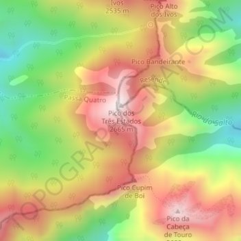
Name: Topografische Karte Serra da Mantiqueira, Höhe, Relief.
Durchschnittliche Höhe: 2.271 m
Minimale Höhe: 1.862 m
Maximale Höhe: 2.634 m
Spenden
Andere topografische Karten
Klicken Sie auf eine Karte, um ihre Topografie, ihre Höhe und ihr Relief anzuzeigen.