
Topografische Karte Great Bend
Interaktive Karte
Klicken Sie auf die Karte, um die Höhe anzuzeigen.
Über diese Karte
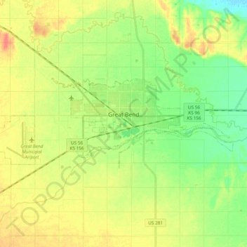
Name: Topografische Karte Great Bend, Höhe, Relief.
Ort: Great Bend, Barton County, Kansas, 67530, United States (38.33027 -98.88497 38.38372 -98.69708)
Durchschnittliche Höhe: 570 m
Minimale Höhe: 549 m
Maximale Höhe: 593 m
Great Bend is located at 38°21′52″N 98°45′53″W / 38.36444°N 98.76472°W / 38.36444; -98.76472 (38.3644567, -98.7648073) at an elevation of 1,850 feet (564 m). Located in central Kansas at the intersection of U.S. Route 281 and U.S. Route 56, Great Bend is 95 miles (153 km) northwest of Wichita, 235 miles (378 km) west-southwest of Kansas City, and 345 miles (555 km) east-southeast of Denver.
Andere topografische Karten
Klicken Sie auf eine Karte, um ihre Topografie, ihre Höhe und ihr Relief anzuzeigen.
Beaver
United States > Kansas > Barton County
Beaver, Barton County, Kansas, United States
Durchschnittliche Höhe: 583 m
Dubuque
United States > Kansas > Barton County
Dubuque, Barton County, Kansas, United States
Durchschnittliche Höhe: 572 m
Odin
United States > Kansas > Barton County
Odin, Barton County, Kansas, 67525, United States
Durchschnittliche Höhe: 565 m
Ellinwood
United States > Kansas > Barton County
Ellinwood, Barton County, Kansas, 67526, United States
Durchschnittliche Höhe: 547 m
Hoisington
United States > Kansas > Barton County
Hoisington, Barton County, Kansas, 67544, United States
Durchschnittliche Höhe: 562 m
Cheyenne Bottoms
United States > Kansas > Barton County
Cheyenne Bottoms, Barton County, Kansas, United States
Durchschnittliche Höhe: 555 m
Barton Lake
United States > Kansas > Barton County
Barton Lake, Barton County, Kansas, United States
Durchschnittliche Höhe: 576 m