
Topografische Karte Odin
Interaktive Karte
Klicken Sie auf die Karte, um die Höhe anzuzeigen.
Über diese Karte
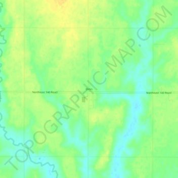
Name: Topografische Karte Odin, Höhe, Relief.
Ort: Odin, Barton County, Kansas, 67525, United States (38.54612 -98.62869 38.58612 -98.58869)
Durchschnittliche Höhe: 565 m
Minimale Höhe: 552 m
Maximale Höhe: 576 m
Andere topografische Karten
Klicken Sie auf eine Karte, um ihre Topografie, ihre Höhe und ihr Relief anzuzeigen.
Beaver
United States > Kansas > Barton County
Beaver, Barton County, Kansas, United States
Durchschnittliche Höhe: 583 m
Dubuque
United States > Kansas > Barton County
Dubuque, Barton County, Kansas, United States
Durchschnittliche Höhe: 572 m
Ellinwood
United States > Kansas > Barton County
Ellinwood, Barton County, Kansas, 67526, United States
Durchschnittliche Höhe: 547 m
Hoisington
United States > Kansas > Barton County
Hoisington, Barton County, Kansas, 67544, United States
Durchschnittliche Höhe: 562 m
Great Bend
United States > Kansas > Barton County
Great Bend, Barton County, Kansas, 67530, United States
Durchschnittliche Höhe: 570 m
Cheyenne Bottoms
United States > Kansas > Barton County
Cheyenne Bottoms, Barton County, Kansas, United States
Durchschnittliche Höhe: 555 m
Barton Lake
United States > Kansas > Barton County
Barton Lake, Barton County, Kansas, United States
Durchschnittliche Höhe: 576 m