
Spenden
Topografische Karte Leacock
Klicken Sie auf die Karte, um die Höhe anzuzeigen.
Spenden
Über diese Karte
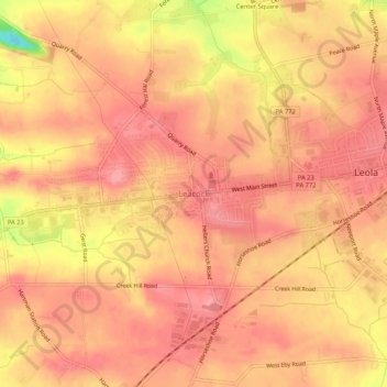
Name: Topografische Karte Leacock, Höhe, Relief.
Durchschnittliche Höhe: 118 m
Minimale Höhe: 48 m
Maximale Höhe: 139 m
Spenden
Andere topografische Karten
Klicken Sie auf eine Karte, um ihre Topografie, ihre Höhe und ihr Relief anzuzeigen.
Spenden
Willow Street
United States > Pennsylvania > Lancaster County > West Lampeter Township
Pennsylvania Route 272 (Willow Street Pike) is the main highway through the community. It is split into two one-way streets, with the northbound lanes following the original main street through the town, and the southbound lanes running four blocks to the west. PA 272 leads north 4 miles (6 km) to the center…
Durchschnittliche Höhe: 119 m
Spenden
Indian Rocks
United States > Pennsylvania > Lancaster County > East Cocalico Township
Durchschnittliche Höhe: 161 m
Gap
United States > Pennsylvania > Lancaster County
Gap is in eastern Lancaster County, in the southern part of Salisbury Township. A small portion of the community extends south into Sadsbury Township. The gap for which the community is named is at an elevation of 580 feet (180 m) above sea level, between Mine Ridge to the west and Gap Hill to the east, both…
Durchschnittliche Höhe: 169 m
Paradise
United States > Pennsylvania > Lancaster County > Paradise Township > Paradise
Durchschnittliche Höhe: 122 m
Spenden