
Vielen Dank für die Unterstützung dieser Website ❤️
Spenden
Spenden
Topografische Karte Willow Street
Klicken Sie auf die Karte, um die Höhe anzuzeigen.
Vielen Dank für die Unterstützung dieser Website ❤️
Spenden
Spenden
Willow Street
Pennsylvania Route 272 (Willow Street Pike) is the main highway through the community. It is split into two one-way streets, with the northbound lanes following the original main street through the town, and the southbound lanes running four blocks to the west. PA 272 leads north 4 miles (6 km) to the center of Lancaster, the county seat, and south 15 miles (24 km) to Wakefield. U.S. Route 222 joins PA 272 in the north part of the CDP (shown as "Mylin Corners" on USGS topographic maps) and leads north into Lancaster but southeast 10 miles (16 km) to Quarryville.
Vielen Dank für die Unterstützung dieser Website ❤️
Spenden
Spenden
Über diese Karte
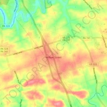
Name: Topografische Karte Willow Street, Höhe, Relief.
Durchschnittliche Höhe: 119 m
Minimale Höhe: 67 m
Maximale Höhe: 165 m
Vielen Dank für die Unterstützung dieser Website ❤️
Spenden
Spenden