
Topografische Karte Dublin Castle
Klicken Sie auf die Karte, um die Höhe anzuzeigen.
Dublin Castle
The Poddle was diverted into the city through archways where the walls adjoined the castle, artificially flooding the moat of the fortress's city elevations. One of these archways and part of the wall survive buried underneath the 18th-century buildings, and are open for public viewing.
Über diese Karte
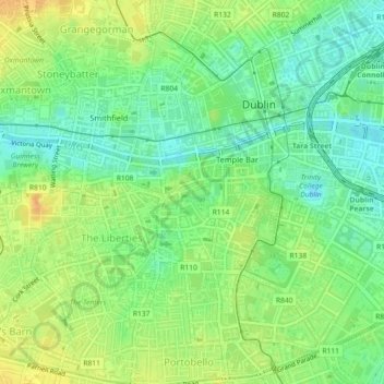
Name: Topografische Karte Dublin Castle, Höhe, Relief.
Durchschnittliche Höhe: 16 m
Minimale Höhe: 1 m
Maximale Höhe: 32 m
Andere topografische Karten
Klicken Sie auf eine Karte, um ihre Topografie, ihre Höhe und ihr Relief anzuzeigen.
Drimnagh Castle
Ireland > County Dublin > Dublin
By the mid-19th century, the castle was owned by the then Marquess of Lansdowne, with Samuel Lewis's Topographical Dictionary of Ireland (printed 1837) stating that it was an "irregular pile", the "property of the Marquess of Lansdowne [..] occupied by Mr. E. Cavanagh".
Durchschnittliche Höhe: 45 m