Geolokalisieren
👉 Easily get elevation data in JSON, GeoTIFF and KML formats using Elevation API
Vielen Dank für die Unterstützung dieser Website ❤️
Spenden

Topografische Karte Rathgar

Klicken Sie auf die Karte, um die Höhe anzuzeigen.

👉 Easily get elevation data in JSON, GeoTIFF and KML formats using Elevation API
Vielen Dank für die Unterstützung dieser Website ❤️
Spenden

Über diese Karte

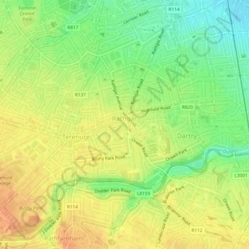
Name: Topografische Karte Rathgar, Höhe, Relief.

Ort: Rathgar, Rathfarnham A ED, Dublin, County Dublin, Leinster, Ireland (53.30374 -6.28252 53.31860 -6.26372)

Durchschnittliche Höhe: 40 m

Minimale Höhe: 18 m

Maximale Höhe: 56 m

👉 Easily get elevation data in JSON, GeoTIFF and KML formats using Elevation API
Vielen Dank für die Unterstützung dieser Website ❤️
Spenden

Andere topografische Karten

Klicken Sie auf eine Karte, um ihre Topografie, ihre Höhe und ihr Relief anzuzeigen.

Poolbeg Lighthouse

Ireland > County Dublin > Dublin

Durchschnittliche Höhe: 0 m

St Anne's Park

Ireland > County Dublin > Dublin

Durchschnittliche Höhe: 13 m

Iveagh Gardens

Ireland > County Dublin > Dublin

Durchschnittliche Höhe: 17 m

Griffith Park

Ireland > County Dublin > Dublin

Durchschnittliche Höhe: 26 m

Vielen Dank für die Unterstützung dieser Website ❤️
Spenden

Tolka Valley Park

Ireland > County Dublin > Dublin

Durchschnittliche Höhe: 44 m

Dublin Castle

Ireland > County Dublin > Dublin

The Poddle was diverted into the city through archways where the walls adjoined the castle, artificially flooding the moat of the fortress's city elevations. One of these archways and part of the wall survive buried underneath the 18th-century buildings, and are open for public viewing.

Durchschnittliche Höhe: 16 m