
Spenden
Topografische Karte Saint-Lô
Klicken Sie auf die Karte, um die Höhe anzuzeigen.
Spenden
Saint-Lô
The square of the town hall was completely redeveloped in the 1990s. The city organised a large demonstration on the occasion of the fiftieth anniversary of the Normandy landings. The edges of the Vire were reconfigured with the rehabilitation of the towpath and the creation of a green beach, at the Place du Quai-à-Tangue. A scow was rebuilt and crossed the river, in order to remember former river traffic. In 2004, the rural area of Bois-Jugan was urbanised, with the creation of housing within a framework of preservation of green spaces and a large aquatic centre. Later, the Des Ronchettes water tower was built following an unusual method for the time, since the tank (strongly resembling a flying saucer) was built at the ground level, then raised by a system of jacks, as the rings composing its body were manufactured. As such, its elevation allows a mounting point for telecommunication (mobile phone, WiMAX, and FM radio) networks.
Spenden
Über diese Karte
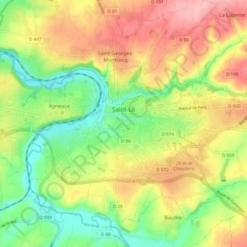
Name: Topografische Karte Saint-Lô, Höhe, Relief.
Ort: Saint-Lô, Manche, Normandy, Metropolitan France, 50000, France (49.08545 -1.12672 49.13906 -1.03573)
Durchschnittliche Höhe: 68 m
Minimale Höhe: 3 m
Maximale Höhe: 140 m
Spenden
Andere topografische Karten
Klicken Sie auf eine Karte, um ihre Topografie, ihre Höhe und ihr Relief anzuzeigen.
Spenden
La Valette
France > Normandy > Manche > Bricquebec-en-Cotentin > Quettetot
Durchschnittliche Höhe: 118 m
Spenden
La Ligotière
France > Normandy > Manche > Villedieu-les-Poêles-Rouffigny > Villedieu-les-Poêles
Durchschnittliche Höhe: 162 m
Spenden
Spenden
Spenden
Spenden
Spenden
Cerisy-la-Salle
France > Normandy > Manche > Cerisy-la-Salle > Cerisy-la-Salle
Durchschnittliche Höhe: 108 m
Spenden