
Spenden
Topografische Karte Les Pas
Klicken Sie auf die Karte, um die Höhe anzuzeigen.
Spenden
Über diese Karte
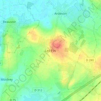
Name: Topografische Karte Les Pas, Höhe, Relief.
Durchschnittliche Höhe: 21 m
Minimale Höhe: 3 m
Maximale Höhe: 52 m
Spenden
Andere topografische Karten
Klicken Sie auf eine Karte, um ihre Topografie, ihre Höhe und ihr Relief anzuzeigen.
Villedieu-les-Poêles
France > Normandy > Manche > Villedieu-les-Poêles-Rouffigny
Durchschnittliche Höhe: 161 m
Spenden
Spenden
Saint-Lô
The square of the town hall was completely redeveloped in the 1990s. The city organised a large demonstration on the occasion of the fiftieth anniversary of the Normandy landings. The edges of the Vire were reconfigured with the rehabilitation of the towpath and the creation of a green beach, at the Place du…
Durchschnittliche Höhe: 68 m
Spenden
Spenden
Spenden
Spenden
Spenden
Spenden
Spenden
Spenden
Spenden
Spenden
Spenden
Spenden
Spenden
Spenden
Spenden
Saint-Lô
The square of the town hall was completely redeveloped in the 1990s. The city organised a large demonstration on the occasion of the fiftieth anniversary of the Normandy landings. The edges of the Vire were reconfigured with the rehabilitation of the towpath and the creation of a green beach, at the Place du…
Durchschnittliche Höhe: 68 m
Spenden
Spenden