
Topografische Karte Aleosan
Klicken Sie auf die Karte, um die Höhe anzuzeigen.
Über diese Karte
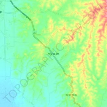
Name: Topografische Karte Aleosan, Höhe, Relief.
Ort: Aleosan, North Cotabato, Soccsksargen, 9415, Philippines (7.11858 124.53740 7.19858 124.61740)
Durchschnittliche Höhe: 44 m
Minimale Höhe: 5 m
Maximale Höhe: 125 m
Andere topografische Karten
Klicken Sie auf eine Karte, um ihre Topografie, ihre Höhe und ihr Relief anzuzeigen.
Magpet
Rice production in Magpet is only 1.16% or 1,028 hectares of the total land area with another 1.50% or 1,115 hectares as potential area due to its land topography, which is mostly hilly or mountainous.
Durchschnittliche Höhe: 597 m
Kabacan
The landscape is characterized by almost regular landscape of flat terrain. The high mountains and rolling hills leaping close to the river plus the narrow plains have varied topographical features. Other features are moderately sloping and strongly sloping.
Durchschnittliche Höhe: 95 m