Geolokalisieren
👉 Easily get elevation data in JSON, GeoTIFF and KML formats using Elevation API
Vielen Dank für die Unterstützung dieser Website ❤️
Spenden

Topografische Karte Hautes Pyrenees

Klicken Sie auf die Karte, um die Höhe anzuzeigen.

👉 Easily get elevation data in JSON, GeoTIFF and KML formats using Elevation API
Vielen Dank für die Unterstützung dieser Website ❤️
Spenden

Hautes Pyrenees

Hautes-Pyrénées consists of several distinct geographical areas. The southern portion, along the border with Spain, consists of mountains such as the Vignemale, the Pic du Midi de Bigorre, and the Neouvielle and Arbizon ranges. A second area consists of low-altitude rolling hills. The northern part of the département consists of largely flat agricultural land. Hautes-Pyrénées has two small territorial exclaves—a remnant from the Middle Ages—located within the neighboring département of Pyrénées-Atlantiques.

Wikipedia (CC-BY-SA 3.0)

👉 Easily get elevation data in JSON, GeoTIFF and KML formats using Elevation API
Vielen Dank für die Unterstützung dieser Website ❤️
Spenden

Über diese Karte

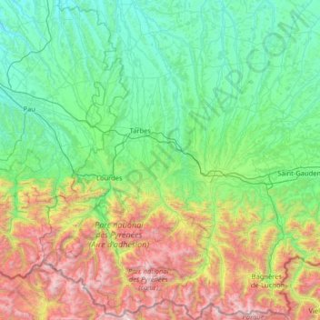
Name: Topografische Karte Hautes Pyrenees, Höhe, Relief.

Ort: Hautes Pyrenees, Occitania, Metropolitan France, France (42.67418 -0.32723 43.61336 0.64614)

Durchschnittliche Höhe: 820 m

Minimale Höhe: 91 m

Maximale Höhe: 3.280 m

👉 Easily get elevation data in JSON, GeoTIFF and KML formats using Elevation API
Vielen Dank für die Unterstützung dieser Website ❤️
Spenden

Andere topografische Karten

Klicken Sie auf eine Karte, um ihre Topografie, ihre Höhe und ihr Relief anzuzeigen.

Saint-Germain

France > Occitania > Aveyron > Millau

Durchschnittliche Höhe: 632 m

Pyrenees

France > Occitania >

In the Western Pyrenees, from the Basque mountains near the Bay of Biscay of the Atlantic Ocean, the average elevation gradually increases from west to east.

Durchschnittliche Höhe: 2.716 m

Bovila

France > Occitania > Lot > Porte-du-Quercy

Durchschnittliche Höhe: 243 m

La Bastide des Fonts

France > Occitania > Aveyron > Cornus

Durchschnittliche Höhe: 694 m

Vielen Dank für die Unterstützung dieser Website ❤️
Spenden

Lamaison

France > Occitania > Gers > Tournan

Durchschnittliche Höhe: 250 m

Pic de Finestrelles

France > Occitania > Pyrénées-Orientales > Eyne

Pic de Finestrelles is a mountain located in the Oriental Pyrenees, on the border of France and Spain. It has an altitude of 2,826 metres (9,272 ft) above sea level.

Durchschnittliche Höhe: 2.502 m

Pic Saint-Loup

France > Occitania > Hérault > Cazevieille

Durchschnittliche Höhe: 276 m

Vielen Dank für die Unterstützung dieser Website ❤️
Spenden

Col de Panissars

France > Occitania > Pyrénées-Orientales > Le Perthus

Durchschnittliche Höhe: 307 m

Labrousse

France > Occitania > Lot > Prayssac

Durchschnittliche Höhe: 123 m

Pic de Finestrelles

France > Occitania > Pyrénées-Orientales > Eyne

Pic de Finestrelles is a mountain located in the Oriental Pyrenees, on the border of France and Spain. It has an altitude of 2,826 metres (9,272 ft) above sea level.

Durchschnittliche Höhe: 2.502 m

Guzet-Neige Prat Mataou

France > Occitania > Ariège > Ustou

Durchschnittliche Höhe: 1.194 m

Vielen Dank für die Unterstützung dieser Website ❤️
Spenden

Bourdials

France > Occitania > Aude > Castans

Durchschnittliche Höhe: 745 m

Escalade

France > Occitania > Gard > Sumène

Durchschnittliche Höhe: 372 m

Cominac

France > Occitania > Ariège > Ercé

Durchschnittliche Höhe: 784 m

Ceyrac

France > Occitania > Aveyron > Gabriac

Durchschnittliche Höhe: 595 m

Vielen Dank für die Unterstützung dieser Website ❤️
Spenden

Roc du Caroux

France > Occitania > Hérault > Rosis

Durchschnittliche Höhe: 731 m

Cominac

France > Occitania > Ariège > Ercé

Durchschnittliche Höhe: 784 m

Le Vernet

France > Occitania > Hérault > Combes

Durchschnittliche Höhe: 471 m

Sets

France > Occitania > Ariège > Bordes-Uchentein

Durchschnittliche Höhe: 920 m

Vielen Dank für die Unterstützung dieser Website ❤️
Spenden

Vives

France > Occitania > Ariège > Mérens-les-Vals

Durchschnittliche Höhe: 1.513 m

la Croix

France > Occitania > Gard > Argilliers > Argilliers

Durchschnittliche Höhe: 91 m

Axiat

France > Occitania > Ariège > Miglos

Durchschnittliche Höhe: 1.038 m

Le Soulier

France > Occitania > Gard > Saint-Martin-de-Valgalgues

Durchschnittliche Höhe: 202 m

Vielen Dank für die Unterstützung dieser Website ❤️
Spenden

Sirach

France > Occitania > Pyrénées-Orientales > Ria-Sirach

Durchschnittliche Höhe: 517 m

La Nauze

France > Occitania > Tarn-et-Garonne > Molières > Molières

Durchschnittliche Höhe: 140 m

Les Vignottes

France > Occitania > Lot > Prendeignes

Durchschnittliche Höhe: 373 m

Les Brousses

France > Occitania > Gard > Molières-sur-Cèze

Durchschnittliche Höhe: 293 m

Vielen Dank für die Unterstützung dieser Website ❤️
Spenden

Tarassac

France > Occitania > Hérault > Mons

Durchschnittliche Höhe: 281 m

Lac Doux

France > Occitania > Tarn-et-Garonne > Loze > Mas d'Estèbe

Durchschnittliche Höhe: 329 m

Laujou

France > Occitania > Ariège > Auzat

Durchschnittliche Höhe: 1.444 m

Cabrillo

France > Occitania > Hérault > Roquebrun

Durchschnittliche Höhe: 167 m

Vielen Dank für die Unterstützung dieser Website ❤️
Spenden

Pré d'en Mathieu

France > Occitania > Ariège > Mijanès

Durchschnittliche Höhe: 1.788 m

Vignemale

France > Occitania > Hautes Pyrenees > Cauterets

Durchschnittliche Höhe: 2.691 m

Laquet de la Cabarère

France > Occitania > Ariège > Ustou

Durchschnittliche Höhe: 2.024 m

Pech Cardou

France > Occitania > Aude > Serres

Durchschnittliche Höhe: 427 m

Vielen Dank für die Unterstützung dieser Website ❤️
Spenden

Mont Valier

France > Occitania > Ariège > Seix

On August 18, 2023, French general Jean-Louis Georgelin fell to his death while hiking on Mont Valier, at an altitude of 2,650 metres (8,690 ft).

Durchschnittliche Höhe: 2.217 m

Balarin

France > Occitania > Gers > Montréal

Durchschnittliche Höhe: 128 m

Bay

France > Occitania > Gard > Canaules-et-Argentières

Durchschnittliche Höhe: 98 m

Loc

France > Occitania > Gers > Caupenne-d'Armagnac

Durchschnittliche Höhe: 108 m

Vielen Dank für die Unterstützung dieser Website ❤️
Spenden

Massip

France > Occitania > Aveyron > Golinhac

Durchschnittliche Höhe: 572 m

Pyrénées 2000

France > Occitania > Pyrénées-Orientales > Bolquère

Durchschnittliche Höhe: 1.784 m

Bordevieille

France > Occitania > Hérault > Riols

Durchschnittliche Höhe: 703 m

Ayez

France > Occitania > Hérault > Olargues

Durchschnittliche Höhe: 324 m

Vielen Dank für die Unterstützung dieser Website ❤️
Spenden

Le Castelas

France > Occitania > Aude > Rennes-le-Château

Durchschnittliche Höhe: 381 m

Leth

France > Occitania > Aveyron > Florentin-la-Capelle

Durchschnittliche Höhe: 490 m

Le Rouve

France > Occitania > Aveyron > Salles-Curan

Durchschnittliche Höhe: 840 m

Le Truc

France > Occitania > Hérault > Loupian

Durchschnittliche Höhe: 35 m

Vielen Dank für die Unterstützung dieser Website ❤️
Spenden

Herede

France > Occitania > Hautes Pyrenees > Lies

Durchschnittliche Höhe: 614 m

Résidence le Mattas

France > Occitania > Gard > Méjannes-le-Clap

Durchschnittliche Höhe: 263 m

Pas de l'Échelle

France > Occitania > Pyrénées-Orientales > Vingrau

Durchschnittliche Höhe: 267 m

Carol

France > Occitania > Hérault > Octon

Durchschnittliche Höhe: 271 m

Vielen Dank für die Unterstützung dieser Website ❤️
Spenden

Lac d'Estom

France > Occitania > Hautes Pyrenees > Cauterets

Durchschnittliche Höhe: 2.194 m

Boirargues

France > Occitania > Hérault > Lattes

Durchschnittliche Höhe: 14 m

Lahore

France > Occitania > Hautes Pyrenees > Viger > Buala

Durchschnittliche Höhe: 569 m

Les Tour

France > Occitania > Aveyron > Druelle Balsac > Druelle

Durchschnittliche Höhe: 582 m

Vielen Dank für die Unterstützung dieser Website ❤️
Spenden

Odeillo

France > Occitania > Pyrénées-Orientales > Font-Romeu-Odeillo-Via

Durchschnittliche Höhe: 1.631 m

Camp Bernard

France > Occitania > Gard > Val-d'Aigoual > Fenouillet

Durchschnittliche Höhe: 636 m

Cirque de Gavarnie

France > Occitania > Hautes Pyrenees > Gavarnie-Gèdre > Gavarnie

Durchschnittliche Höhe: 2.364 m

Les Cloutets

France > Occitania > Ariège > Soulan

Durchschnittliche Höhe: 852 m

Vielen Dank für die Unterstützung dieser Website ❤️
Spenden

Plateau de Beille

France > Occitania > Ariège > Albiès

Durchschnittliche Höhe: 1.659 m

Mont Aigoual

France > Occitania > Gard > Val-d'Aigoual

Durchschnittliche Höhe: 1.355 m

Cournou

France > Occitania > Lot > Saint-Vincent-Rive-d'Olt

Durchschnittliche Höhe: 243 m

Le Mauron

France > Occitania > Aveyron > Maleville

Durchschnittliche Höhe: 451 m

Vielen Dank für die Unterstützung dieser Website ❤️
Spenden

Cambié

France > Occitania > Ariège > Serres-sur-Arget

Durchschnittliche Höhe: 640 m

Petit Jean

France > Occitania > Haute-Garonne > Lapeyrère

Durchschnittliche Höhe: 324 m

Pic de la Vinyola

France > Occitania > Pyrénées-Orientales > Porta

Durchschnittliche Höhe: 2.502 m

Montagnac

France > Occitania > Haute-Garonne > Saint-Frajou

Durchschnittliche Höhe: 294 m

Vielen Dank für die Unterstützung dieser Website ❤️
Spenden

La Lune

France > Occitania > Haute-Garonne > Terrebasse

Durchschnittliche Höhe: 321 m

Taulan

France > Occitania > Aveyron > Roquefort-sur-Soulzon

Durchschnittliche Höhe: 606 m

Le Contourès

France > Occitania > Aveyron > Castanet

Durchschnittliche Höhe: 635 m

Vielen Dank für die Unterstützung dieser Website ❤️
Spenden

Lérab Ling

France > Occitania > Hérault > Roqueredonde

Durchschnittliche Höhe: 726 m

Les Boules

France > Occitania > Lot > Bellefont-La Rauze

Durchschnittliche Höhe: 276 m

La Trivalle

France > Occitania > Hérault > Mons

Durchschnittliche Höhe: 297 m

Le Bez

France > Occitania > Tarn > Mirandol-Bourgnounac

Durchschnittliche Höhe: 373 m

Vielen Dank für die Unterstützung dieser Website ❤️
Spenden

Issis

France > Occitania > Aveyron > Creissels

Durchschnittliche Höhe: 540 m

Calcomier

France > Occitania > Aveyron > Rodez

Durchschnittliche Höhe: 570 m

Tucon

France > Occitania > Gers > Gazax-et-Baccarisse

Durchschnittliche Höhe: 196 m

Port-Leucate

France > Occitania > Aude > Leucate

Durchschnittliche Höhe: 0 m

Vielen Dank für die Unterstützung dieser Website ❤️
Spenden

Revers

France > Occitania > Lot > Le Vigan-en-Quercy

Durchschnittliche Höhe: 262 m

Badio

France > Occitania > Tarn-et-Garonne > Castelferrus

Durchschnittliche Höhe: 101 m

Mas Ponchet

France > Occitania > Lot > Cressensac-Sarrazac

Durchschnittliche Höhe: 215 m

Vielen Dank für die Unterstützung dieser Website ❤️
Spenden

Pech d'Aspe

France > Occitania > Aude > Mas-des-Cours

Durchschnittliche Höhe: 349 m

La Quille

France > Occitania > Hérault > Les Plans

Durchschnittliche Höhe: 643 m

Riols

France > Occitania > Hérault > Graissessac

Durchschnittliche Höhe: 499 m

Cantobre

France > Occitania > Aveyron > Nant

Durchschnittliche Höhe: 666 m

Vielen Dank für die Unterstützung dieser Website ❤️
Spenden

Pic de Nore

France > Occitania > Aude > Pradelles-Cabardès

Durchschnittliche Höhe: 1.063 m

Via

France > Occitania > Pyrénées-Orientales > Font-Romeu-Odeillo-Via

Durchschnittliche Höhe: 1.551 m

Mont Béas

France > Occitania > Ariège > Le Port

Durchschnittliche Höhe: 1.394 m

Vielen Dank für die Unterstützung dieser Website ❤️
Spenden

Tarassac

France > Occitania > Hérault > Mons

Durchschnittliche Höhe: 281 m

Lac de Gaube

France > Occitania > Hautes Pyrenees > Cauterets

The lake is situated in an altitude of 1725 m, an egg-shaped form stretching itself along a north–south axis in the valley of Gaube. This steep-sided valley is located at the foot of the Vignemale (3298M). The lake is surrounded by the peak Mayouret (2688 m) to the east, the big Peak of the Paloumères (2720…

Durchschnittliche Höhe: 2.079 m

Les Nières

France > Occitania > Hérault > Saint-Gervais-sur-Mare

Durchschnittliche Höhe: 470 m

Colline de Chabanette

France > Occitania > Hérault > Sète

Durchschnittliche Höhe: 28 m

Vielen Dank für die Unterstützung dieser Website ❤️
Spenden

Issis

France > Occitania > Aveyron > Creissels

Durchschnittliche Höhe: 540 m

La Mothe

France > Occitania > Tarn > Castelnau-de-Lévis

Durchschnittliche Höhe: 203 m

Belot

France > Occitania > Hérault > La Salvetat-sur-Agout

Durchschnittliche Höhe: 753 m

Réals

France > Occitania > Hérault > Cessenon-sur-Orb

Durchschnittliche Höhe: 89 m

Vielen Dank für die Unterstützung dieser Website ❤️
Spenden