
Spenden
Topografische Karte Dauis
Klicken Sie auf die Karte, um die Höhe anzuzeigen.
Spenden
Über diese Karte
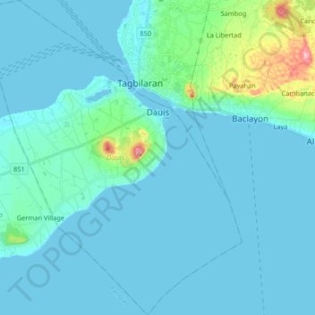
Name: Topografische Karte Dauis, Höhe, Relief.
Ort: Dauis, Bohol, Central Visayas, 6339, Philippines (9.52148 123.76752 9.68244 123.90885)
Durchschnittliche Höhe: 20 m
Minimale Höhe: -2 m
Maximale Höhe: 201 m
Spenden
Andere topografische Karten
Klicken Sie auf eine Karte, um ihre Topografie, ihre Höhe und ihr Relief anzuzeigen.
Spenden
Spenden
Alburquerque
The central part of municipality, from the east extending toward northwest is characterized by rolling to moderately steep terrain (18-30% slope), with ground elevation ranging from 80 to 131 m (262 to 430 ft) amsl. The area in northeastern and southwestern part is characterized by steep terrain (30–50%…
Durchschnittliche Höhe: 36 m
Spenden
Spenden
Spenden
Spenden
Spenden
Spenden
Calape
Most of the coastal area is a fairly level plain that gradually rises into rolling hills of coralline limestone. The highest point in Calape is Mount Candungao in the eastern portion of the town, with an elevation of 150 metres (500 ft) above sea level.
Durchschnittliche Höhe: 46 m
Spenden
Loon
Loon is composed of land mass, coastlines and natural waters and has a relatively rolling topography consisting of moderate hills, rolling plains, sparse plateaus interspersed with valleys, and some ravines.
Durchschnittliche Höhe: 84 m
Spenden
Spenden
Spenden
Spenden
Spenden
Spenden
Spenden
Spenden
Spenden
Spenden
Spenden
Spenden
Spenden
Spenden
Spenden
Spenden