
Topografische Karte Farmland
Interaktive Karte
Klicken Sie auf die Karte, um die Höhe anzuzeigen.
Über diese Karte
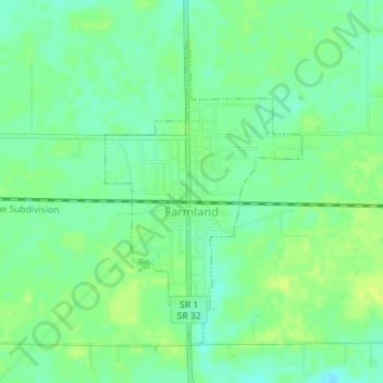
Name: Topografische Karte Farmland, Höhe, Relief.
Ort: Farmland, Randolph County, Indiana, United States (40.17846 -85.13548 40.19991 -85.11728)
Durchschnittliche Höhe: 318 m
Minimale Höhe: 309 m
Maximale Höhe: 325 m
Andere topografische Karten
Klicken Sie auf eine Karte, um ihre Topografie, ihre Höhe und ihr Relief anzuzeigen.
Union City
United States > Indiana > Randolph County
Union City, Randolph County, Indiana, United States
Durchschnittliche Höhe: 333 m
Parker City
United States > Indiana > Randolph County
Parker City, Randolph County, Indiana, 47368, United States
Durchschnittliche Höhe: 312 m
Windsor
United States > Indiana > Randolph County
Windsor, Randolph County, Indiana, 47368, United States
Durchschnittliche Höhe: 312 m
Lynn
United States > Indiana > Randolph County
Lynn, Randolph County, Indiana, United States
Durchschnittliche Höhe: 356 m
Modoc
United States > Indiana > Randolph County
Modoc, Randolph County, Indiana, United States
Durchschnittliche Höhe: 355 m
Winchester
United States > Indiana > Randolph County
Winchester, Randolph County, Indiana, 47494, United States
Durchschnittliche Höhe: 335 m