Geolokalisieren
👉 Easily get elevation data in JSON, GeoTIFF and KML formats using Elevation API
Vielen Dank für die Unterstützung dieser Website ❤️
Spenden

Topografische Karte Buchenau

Klicken Sie auf die Karte, um die Höhe anzuzeigen.

👉 Easily get elevation data in JSON, GeoTIFF and KML formats using Elevation API
Vielen Dank für die Unterstützung dieser Website ❤️
Spenden

Über diese Karte

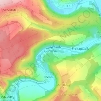
Name: Topografische Karte Buchenau, Höhe, Relief.

Ort: Buchenau, Amt Creuzburg, Hainich-Werratal, Wartburgkreis, Thuringia, 99831, Germany (51.05285 10.25339 51.09285 10.29339)

Durchschnittliche Höhe: 284 m

Minimale Höhe: 177 m

Maximale Höhe: 422 m

👉 Easily get elevation data in JSON, GeoTIFF and KML formats using Elevation API
Vielen Dank für die Unterstützung dieser Website ❤️
Spenden

Andere topografische Karten

Klicken Sie auf eine Karte, um ihre Topografie, ihre Höhe und ihr Relief anzuzeigen.

Eisenach

Germany > Thuringia > Wartburgkreis

Eisenach is at the northern edge of the Thuringian Forest, at an elevation of about 220 m. The terrain is hilly, and to the south also mountainous (up to 460 m of elevation), with the central Hörsel valley crossing the town in east–west direction. The Nesse river enters the Hörsel river in Eisenach after…

Durchschnittliche Höhe: 298 m

Stadtlengsfeld

Germany > Thuringia > Wartburgkreis > Dermbach

Durchschnittliche Höhe: 382 m

36460

Germany > Thuringia > Wartburgkreis

Durchschnittliche Höhe: 308 m

Amt Creuzburg

Germany > Thuringia > Wartburgkreis

Durchschnittliche Höhe: 294 m

Vielen Dank für die Unterstützung dieser Website ❤️
Spenden

Eisenach

Germany > Thuringia > Wartburgkreis

Eisenach is situated at the northern edge of the Thuringian Forest, at an elevation of about 220 m. The terrain is hilly, to the south also mountainous (up to 460 m of elevation), with the central Hörsel valley crossing the town in east-western direction. The Nesse river enters the Hörsel river in Eisenach…

Durchschnittliche Höhe: 298 m

Geisa

Germany > Thuringia > Wartburgkreis > Geisa

Durchschnittliche Höhe: 332 m

Gerstungen

Germany > Thuringia > Wartburgkreis

Durchschnittliche Höhe: 302 m

Bad Salzungen

Germany > Thuringia > Wartburgkreis

Durchschnittliche Höhe: 347 m

Vielen Dank für die Unterstützung dieser Website ❤️
Spenden

Bad Liebenstein

Germany > Thuringia > Wartburgkreis

Durchschnittliche Höhe: 424 m