
Topografische Karte Jessieville
Interaktive Karte
Klicken Sie auf die Karte, um die Höhe anzuzeigen.
Über diese Karte
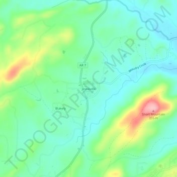
Name: Topografische Karte Jessieville, Höhe, Relief.
Ort: Jessieville, Garland County, Arkansas, 71910, United States (34.68120 -93.08157 34.72120 -93.04157)
Durchschnittliche Höhe: 238 m
Minimale Höhe: 193 m
Maximale Höhe: 351 m
Andere topografische Karten
Klicken Sie auf eine Karte, um ihre Topografie, ihre Höhe und ihr Relief anzuzeigen.
Hot Springs National Park
United States > Arkansas > Garland County > Hot Springs
Hot Springs National Park, Hot Springs, Garland County, Arkansas, 71901, United States
Durchschnittliche Höhe: 227 m
Hot Springs
United States > Arkansas > Garland County
Hot Springs, Garland County, Arkansas, United States
Durchschnittliche Höhe: 172 m
Hot Springs Village
United States > Arkansas > Garland County
Hot Springs Village, Garland County, Arkansas, 71909, United States
Durchschnittliche Höhe: 226 m
Piney
United States > Arkansas > Garland County > Hot Springs
Piney, Hot Springs, Garland County, Arkansas, United States
Durchschnittliche Höhe: 146 m
Bear
United States > Arkansas > Garland County
Bear, Garland County, Arkansas, 71968, United States
Durchschnittliche Höhe: 216 m
Sunshine
United States > Arkansas > Garland County
Sunshine, Garland County, Arkansas, 71968, United States
Durchschnittliche Höhe: 155 m
Crystal Springs
United States > Arkansas > Garland County
Crystal Springs, Garland County, Arkansas, United States
Durchschnittliche Höhe: 227 m
Buckville Public Use Area
United States > Arkansas > Garland County
Buckville Public Use Area, Garland County, Arkansas, United States
Durchschnittliche Höhe: 185 m
Rockwell
United States > Arkansas > Garland County > Rockwell
Rockwell, Garland County, Arkansas, United States
Durchschnittliche Höhe: 138 m
Pleasant Hill
United States > Arkansas > Garland County
Pleasant Hill, Garland County, Arkansas, United States
Durchschnittliche Höhe: 152 m
Lake Hamilton
United States > Arkansas > Garland County > Hot Springs
Lake Hamilton, Hot Springs, Garland County, Arkansas, United States
Durchschnittliche Höhe: 130 m
Mountain Pine
United States > Arkansas > Garland County
Mountain Pine, Garland County, Arkansas, United States
Durchschnittliche Höhe: 159 m
Fountain Lake
United States > Arkansas > Garland County
Fountain Lake, Garland County, Arkansas, 71901, United States
Durchschnittliche Höhe: 165 m
Royal
United States > Arkansas > Garland County
Royal, Garland County, Arkansas, 71968, United States
Durchschnittliche Höhe: 160 m
Lonsdale
United States > Arkansas > Garland County
Lonsdale, Garland County, Arkansas, 72087, United States
Durchschnittliche Höhe: 149 m
Mountain Valley
United States > Arkansas > Garland County > Hot Springs Village > Mountain Valley
Mountain Valley, Hot Springs Village, Garland County, Arkansas, 71909, United States
Durchschnittliche Höhe: 248 m
Blue Springs
United States > Arkansas > Garland County > Blue Springs
Blue Springs, Garland County, Arkansas, 71910, United States
Durchschnittliche Höhe: 256 m
Pearcy
United States > Arkansas > Garland County
Pearcy, Garland County, Arkansas, United States
Durchschnittliche Höhe: 191 m
Hot Springs
United States > Arkansas > Garland County > Hot Springs
Hot Springs, Garland County, Arkansas, 71901, United States
Durchschnittliche Höhe: 187 m