
Topografische Karte Hot Springs
Interaktive Karte
Klicken Sie auf die Karte, um die Höhe anzuzeigen.
Über diese Karte
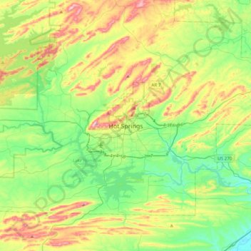
Name: Topografische Karte Hot Springs, Höhe, Relief.
Ort: Hot Springs, Garland County, Arkansas, 71901, United States (34.34384 -93.21524 34.66384 -92.89524)
Durchschnittliche Höhe: 187 m
Minimale Höhe: 66 m
Maximale Höhe: 419 m
Andere topografische Karten
Klicken Sie auf eine Karte, um ihre Topografie, ihre Höhe und ihr Relief anzuzeigen.
Hot Springs National Park
United States > Arkansas > Garland County > Hot Springs
Hot Springs National Park, Hot Springs, Garland County, Arkansas, 71901, United States
Durchschnittliche Höhe: 227 m
Piney
United States > Arkansas > Garland County > Hot Springs
Piney, Hot Springs, Garland County, Arkansas, United States
Durchschnittliche Höhe: 146 m
Lake Hamilton
United States > Arkansas > Garland County > Hot Springs
Lake Hamilton, Hot Springs, Garland County, Arkansas, United States
Durchschnittliche Höhe: 130 m