
Topografische Karte Kedron Brook
Klicken Sie auf die Karte, um die Höhe anzuzeigen.
Über diese Karte
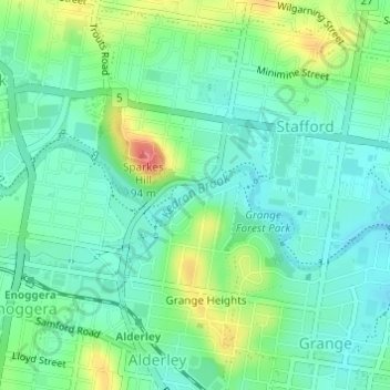
Name: Topografische Karte Kedron Brook, Höhe, Relief.
Ort: Kedron Brook, Brisbane, Queensland, 4051, Australia (-27.41626 153.00232 -27.41259 153.00880)
Durchschnittliche Höhe: 39 m
Minimale Höhe: 16 m
Maximale Höhe: 91 m
Andere topografische Karten
Klicken Sie auf eine Karte, um ihre Topografie, ihre Höhe und ihr Relief anzuzeigen.
Bribie Island
Australia > Queensland > Brisbane
Bribie Island, located in Queensland, Australia, is a low-lying, elongated landmass stretching approximately 34 kilometers (21 miles) in length and up to 8 kilometers (5 miles) at its widest point. Composed predominantly of coastal sand plains, the island features two large, low-lying dunes extending…
Durchschnittliche Höhe: 6 m
Lamb Island
Australia > Queensland > Brisbane
The island is in the southern part of Moreton Bay between the Queensland mainland and North Stradbroke Island. It is within the Moreton Bay Marine Park. The elevation ranges from 0 to 26 metres (0 to 85 ft) above sea level. The land use on the island is predominantly residential.
Durchschnittliche Höhe: 4 m