
Topografische Karte Bribie Island
Klicken Sie auf die Karte, um die Höhe anzuzeigen.
Bribie Island
Bribie Island, located in Queensland, Australia, is a low-lying, elongated landmass stretching approximately 34 kilometers (21 miles) in length and up to 8 kilometers (5 miles) at its widest point. Composed predominantly of coastal sand plains, the island features two large, low-lying dunes extending northwestward. To the east, the island is bordered by the Pacific Ocean, while to the west, it is separated from the mainland by the Pumicestone Passage, a narrow waterway that has experienced significant morphological changes due to natural events. The island's terrain is characterized by eucalypt forests, banksias, and heathlands, with extensive mangrove forests along the western shoreline.
Über diese Karte
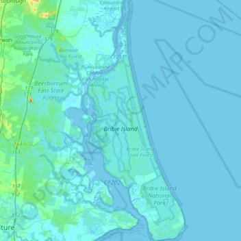
Name: Topografische Karte Bribie Island, Höhe, Relief.
Durchschnittliche Höhe: 6 m
Minimale Höhe: -2 m
Maximale Höhe: 124 m
Andere topografische Karten
Klicken Sie auf eine Karte, um ihre Topografie, ihre Höhe und ihr Relief anzuzeigen.