
Spenden
Topografische Karte Barweiler
Klicken Sie auf die Karte, um die Höhe anzuzeigen.
Spenden
Über diese Karte
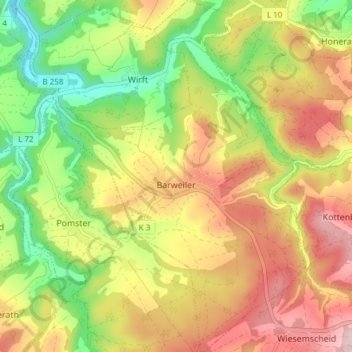
Name: Topografische Karte Barweiler, Höhe, Relief.
Durchschnittliche Höhe: 430 m
Minimale Höhe: 303 m
Maximale Höhe: 558 m
Spenden
Andere topografische Karten
Klicken Sie auf eine Karte, um ihre Topografie, ihre Höhe und ihr Relief anzuzeigen.
Eifel
Germany > Rhineland-Palatinate > Landkreis Ahrweiler > Adenau
The Eifel is in the Atlantic climate zone with its relatively high precipitation; winters that are moderately cold and long with periods of snow; and summers that are often humid and cool. The prevailing wind is west/southwest. A relatively dry and milder climate prevails in the wind and rain shadow of the…
Durchschnittliche Höhe: 585 m
Bengen
Germany > Rhineland-Palatinate > Landkreis Ahrweiler > Grafschaft
Durchschnittliche Höhe: 168 m
Spenden
Beller
Germany > Rhineland-Palatinate > Landkreis Ahrweiler > Grafschaft
Durchschnittliche Höhe: 213 m
Eifel
Germany > Rhineland-Palatinate > Landkreis Ahrweiler > Adenau
The Eifel is in the Atlantic climate zone with its relatively high precipitation; winters that are moderately cold and long with periods of snow; and summers that are often humid and cool. The prevailing wind is west/southwest. A relatively dry and milder climate prevails in the wind and rain shadow of the…
Durchschnittliche Höhe: 585 m
Altenburg
Germany > Rhineland-Palatinate > Landkreis Ahrweiler > Altenburg
Durchschnittliche Höhe: 288 m